IMAGES TAKEN NEAR TO
TS6 7JS
Introduction
This page details the photographs taken nearby to TS6 7JS by members of the Geograph project.
The Geograph project started in 2005 with the aim of publishing, organising and preserving representative images for every square kilometre of Great Britain, Ireland and the Isle of Man.

There are currently over 7.5m images from over14,400 individuals and you can help contribute to the project by visiting https://www.geograph.org.uk
Image Map
Images are licensed for reuse under creativecommons.org/licenses/by-sa/2.0
Notes
- Clicking on the map will re-center to the selected point.
- The higher the marker number, the further away the image location is from the centre of the postcode.
Image Listing (2 Images Found)
Images are licensed for reuse under creativecommons.org/licenses/by-sa/2.0
Image
Details
Distance
1
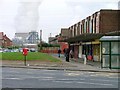
Slater Road Shops, Grangetown
Looking east towards Teesside Power Station.
Image: © Mick Garratt
Taken: 5 Dec 2005
0.12 miles
2
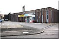
Grangetown Library
This photograph shows a view of Grangetown Library which is located on Birchington Avenue near the Church of St Hilda. The church tower can be seen standing behind the library building and a part of the Eston Hills appears just to the left of it. The picture was taken looking in a south-south-westerly direction towards Eston.
Image: © Philip Barker
Taken: 1 Apr 2010
0.23 miles