IMAGES TAKEN NEAR TO
Tees Dock, MIDDLESBROUGH, TS6 6UD
Introduction
This page details the photographs taken nearby to Tees Dock, TS6 6UD by members of the Geograph project.
The Geograph project started in 2005 with the aim of publishing, organising and preserving representative images for every square kilometre of Great Britain, Ireland and the Isle of Man.

There are currently over 7.5m images from over14,400 individuals and you can help contribute to the project by visiting https://www.geograph.org.uk
Image Map
Images are licensed for reuse under creativecommons.org/licenses/by-sa/2.0
Notes
- Clicking on the map will re-center to the selected point.
- The higher the marker number, the further away the image location is from the centre of the postcode.
Image Listing (7 Images Found)
Images are licensed for reuse under creativecommons.org/licenses/by-sa/2.0
Image
Details
Distance
2
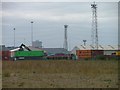
Teesport
All on reclaimed land in the Tees estuary.
Image: © Mick Garratt
Taken: 3 Oct 2005
0.03 miles
4
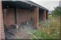
Bike Sheds, Teesport
Leftover from a time when the workforce at Teesport was much higher.
Image: © Mick Garratt
Taken: 18 Aug 2009
0.07 miles
5

Tide's Out
A foy boat in dry dock. Foyboatmen provide mooring services for ships entering the port from handling the ropes to emptying the toilets. See http://www.teesfoyboatmen.co.uk/pages/page.php?page=1
Image: © Mick Garratt
Taken: 18 Aug 2009
0.08 miles

7
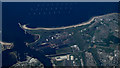
River Tees Mouth from the air
Even from this distance, industrialisation is very evident.
Image: © Thomas Nugent
Taken: 3 Jun 2013
0.13 miles