IMAGES TAKEN NEAR TO
Church Lane, MIDDLESBROUGH, TS6 6TR
Introduction
This page details the photographs taken nearby to Church Lane, TS6 6TR by members of the Geograph project.
The Geograph project started in 2005 with the aim of publishing, organising and preserving representative images for every square kilometre of Great Britain, Ireland and the Isle of Man.

There are currently over 7.5m images from over14,400 individuals and you can help contribute to the project by visiting https://www.geograph.org.uk
Image Map
Images are licensed for reuse under creativecommons.org/licenses/by-sa/2.0
Notes
- Clicking on the map will re-center to the selected point.
- The higher the marker number, the further away the image location is from the centre of the postcode.
Image Listing (12 Images Found)
Images are licensed for reuse under creativecommons.org/licenses/by-sa/2.0
Image
Details
Distance
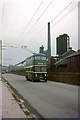
1
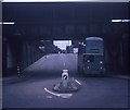
A Trolleybus under the bridge at Grangetown
Taken in July 1970, this photo shows a Sunbeam F4 trolleybus 4 (GAJ 14) with Roe 61-seater bodywork on a private tour of the area's trolleybus system going under a railway bridge in Bolckow Road near the junction with Eston Road. This bridge carried the Bolckow Vaughan Private Railway to the Dorman Long steelworks nearby, but has long since been dismantled and the whole area is completely different today.
Image: © David Hillas
Taken: 18 Jul 1970
0.03 miles
2
No room to spare. A Teesside trolleybus on Bolckow Road, Grangetown ? 1971
Just inches to spare under the bridge which carry the internal railway of the South Bank Ironworks. The bridge has disappeared almost without trace, with just some of the retaining walls remaining.
This is one of a series of views featuring buses in the 60s, 70s, and 80s. http://www.geograph.org.uk/search.php?i=2114547&displayclass=slide
Image: © Alan Murray-Rust
Taken: 23 Mar 1971
0.03 miles
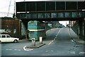
3
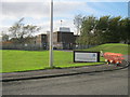
Telephone Exchange near Bolckrow Road
This photograph shows a view of the telephone exchange that is located at the junction of Church Lane and North Slip Road in the South Bank area of Teesside. The picture was taken from North Slip Road looking in a north-north-westerly direction towards the A66 road.
Image: © Philip Barker
Taken: 1 Apr 2010
0.04 miles
4
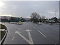
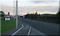
Intersection on the A66
Intersection with Eston Road (towards camera) and Church Lane.
The footway on the right constitutes part of the diversion of the Teesdale Way and England Coast Path. The diversion was necessitated by the closure of a 2 km section of the Black Path since November 2015 during the decommissioning of the old Sahaviriya Steel Industries (SSI) site (see Image). The diversion adds a further 2 km to the total length of the path.
Image: © Oliver Dixon
Taken: 21 Mar 2017
0.06 miles
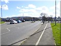
6
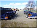
West Lane, Grangetown
Part of an industrial estate on the north side of the A66.
Image: © Oliver Dixon
Taken: 21 Mar 2017
0.16 miles
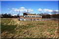
7
Tata Research Centre in Eston Road Grangetown
Image: © Peter Robinson
Taken: 30 Oct 2011
0.19 miles
9
British Trolleybuses - Teesside
The Teesside Railless Transport Board was a joint operation between Middlesbrough Corporation and Eston UDC. It was built to serve the steelworks along the south bank of the River Tees. It was the only trolleybus system operating after the 2nd World War which had not previously been a tramway.
In this picture the trolleybus is passing one of the coking plants which manufactured coke for the blast furnaces. This plant has completely disappeared, although a nearby plant still exists as the last reminder of steelworks in the South Bank district itself. Steelmaking is now concentrated further east in Lackenby and Redcar.
For a slide show of British Trolleybuses in the late 60s http://www.geograph.org.uk/search.php?i=1773236&displayclass=slide
Image: © Alan Murray-Rust
Taken: 26 Mar 1966
0.22 miles
10
Eston Road
Intended to have been taken from the same spot as Image The ironworks on the right have long since gone although pre-cast concrete fencing looks the same. The iron and steel industry is still represented by Corus's Ironopolis research complex on the left.
Image: © Mick Garratt
Taken: 8 Nov 2007
0.23 miles