IMAGES TAKEN NEAR TO
Normanby Road, MIDDLESBROUGH, TS6 6SG
Introduction
This page details the photographs taken nearby to Normanby Road, TS6 6SG by members of the Geograph project.
The Geograph project started in 2005 with the aim of publishing, organising and preserving representative images for every square kilometre of Great Britain, Ireland and the Isle of Man.

There are currently over 7.5m images from over14,400 individuals and you can help contribute to the project by visiting https://www.geograph.org.uk
Image Map
Images are licensed for reuse under creativecommons.org/licenses/by-sa/2.0
Notes
- Clicking on the map will re-center to the selected point.
- The higher the marker number, the further away the image location is from the centre of the postcode.
Image Listing (3 Images Found)
Images are licensed for reuse under creativecommons.org/licenses/by-sa/2.0
Image
Details
Distance
1
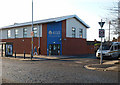
South Bank's new police station
Police station on Normanby Road built to replace this one: Image
Image: © Stephen McCulloch
Taken: 29 Nov 2007
0.12 miles
3
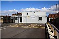
Eston Grange NHS Health Care Centre
This photograph shows a view of the temporary accommodation used to house the Eston Grange NHS Health Care Centre. It is located near the junction of Queen Street and Victoria Road in South Bank within the TS6 postal area of Teesside. The picture was taken from the car park looking in a north-easterly direction towards Redcar.
Image: © Philip Barker
Taken: 1 Apr 2010
0.24 miles