IMAGES TAKEN NEAR TO
Napier Street, MIDDLESBROUGH, TS6 6DE
Introduction
This page details the photographs taken nearby to Napier Street, TS6 6DE by members of the Geograph project.
The Geograph project started in 2005 with the aim of publishing, organising and preserving representative images for every square kilometre of Great Britain, Ireland and the Isle of Man.

There are currently over 7.5m images from over14,400 individuals and you can help contribute to the project by visiting https://www.geograph.org.uk
Image Map
Images are licensed for reuse under creativecommons.org/licenses/by-sa/2.0
Notes
- Clicking on the map will re-center to the selected point.
- The higher the marker number, the further away the image location is from the centre of the postcode.
Image Listing (31 Images Found)
Images are licensed for reuse under creativecommons.org/licenses/by-sa/2.0
Image
Details
Distance
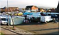
2

South Bank Market
Friday is market day.
Image: © Mick Garratt
Taken: 1 Dec 2006
0.02 miles
3
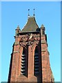
Middlesbrough Road, South Bank
Once the main road into South Bank. The clock on the tower of St Peter's Church gives the time away.
Image: © Mick Garratt
Taken: 2 Dec 2006
0.06 miles
5
South Bank Market
Rather depleted with plenty of spare space. I suppose the traders can not compete with the nearby Asda.
Image: © Mick Garratt
Taken: 2 Dec 2006
0.07 miles

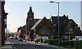
10
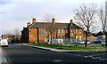
South Bank Police Station, Middlesbrough Road
A new building is under construction around the corner.
Image: © Mick Garratt
Taken: 1 Dec 2006
0.10 miles