IMAGES TAKEN NEAR TO
Nelson Court, MIDDLESBROUGH, TS6 6BL
Introduction
This page details the photographs taken nearby to Nelson Court, TS6 6BL by members of the Geograph project.
The Geograph project started in 2005 with the aim of publishing, organising and preserving representative images for every square kilometre of Great Britain, Ireland and the Isle of Man.

There are currently over 7.5m images from over14,400 individuals and you can help contribute to the project by visiting https://www.geograph.org.uk
Image Map
Images are licensed for reuse under creativecommons.org/licenses/by-sa/2.0
Notes
- Clicking on the map will re-center to the selected point.
- The higher the marker number, the further away the image location is from the centre of the postcode.
Image Listing (35 Images Found)
Images are licensed for reuse under creativecommons.org/licenses/by-sa/2.0
Image
Details
Distance
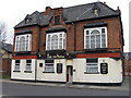
2
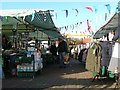
South Bank Market
Friday is market day.
Image: © Mick Garratt
Taken: 1 Dec 2006
0.14 miles
6
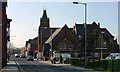
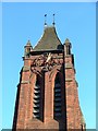
Middlesbrough Road, South Bank
Once the main road into South Bank. The clock on the tower of St Peter's Church gives the time away.
Image: © Mick Garratt
Taken: 2 Dec 2006
0.16 miles
8
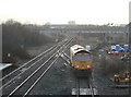
Heading for Middlesbrough
The locomotive seen in http://www.geograph.org.uk/photo/1730614 is proceeding towards Middlesbrough where the 4 track section east of South Bank Station merges to just 2 tracks.
Image: © Alan Murray-Rust
Taken: 9 Feb 2010
0.17 miles
9
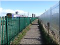
The Black Path at South Bank
The Black Path follows the railway for much of the distance between Middlesbrough and Redcar. For the sake of completeness it has been designated as part of both the Teesdale Way and more recently the England Coast Path. However, the setting of the path through the industrial and post-industrial landscape of lower Tees-side must surely make it the least attractive section of any National Trail.
Here just west of South Bank station, the train to Redcar is passing on the left. An industrial site is behind the high railings to the right.
Image: © Oliver Dixon
Taken: 21 Mar 2017
0.17 miles
10
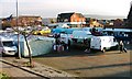
South Bank Market
Rather depleted with plenty of spare space. I suppose the traders can not compete with the nearby Asda.
Image: © Mick Garratt
Taken: 2 Dec 2006
0.18 miles