IMAGES TAKEN NEAR TO
Old Station Road, MIDDLESBROUGH, TS6 6AD
Introduction
This page details the photographs taken nearby to Old Station Road, TS6 6AD by members of the Geograph project.
The Geograph project started in 2005 with the aim of publishing, organising and preserving representative images for every square kilometre of Great Britain, Ireland and the Isle of Man.

There are currently over 7.5m images from over14,400 individuals and you can help contribute to the project by visiting https://www.geograph.org.uk
Image Map
Images are licensed for reuse under creativecommons.org/licenses/by-sa/2.0
Notes
- Clicking on the map will re-center to the selected point.
- The higher the marker number, the further away the image location is from the centre of the postcode.
Image Listing (15 Images Found)
Images are licensed for reuse under creativecommons.org/licenses/by-sa/2.0
Image
Details
Distance
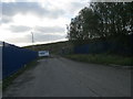
2
Electric Sub-Station, Salisbury Street
I assume this was a sub-station sited on the corner of Salisbury Street with the old Middlesbrough Road.
Image: © Mick Garratt
Taken: 13 Dec 2006
0.14 miles
3
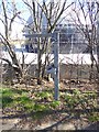
Boots on the Teesdale Way
At various points along the Teesdale Way, a pair of metal boots confirms the way.
Image: © Oliver Dixon
Taken: 21 Mar 2017
0.16 miles
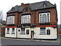
4
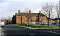
South Bank Police Station, Middlesbrough Road
A new building is under construction around the corner.
Image: © Mick Garratt
Taken: 1 Dec 2006
0.18 miles
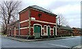
5
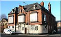
The Victoria
Middlesbrough Road, opposite the police station.
Image: © Mick Garratt
Taken: 2 Dec 2006
0.18 miles
7
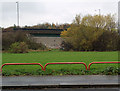
Bricked-up bridge
Carrying Middlesbrough Road over disused mineral railway.
Taken from Old Middlesbrough Road.
Image: © Stephen McCulloch
Taken: 20 Nov 2007
0.19 miles
8
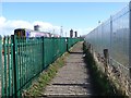
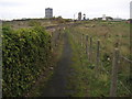
The Black Path at South Bank
The Black Path follows the railway for much of the distance between Middlesbrough and Redcar. For the sake of completeness it has been designated as part of both the Teesdale Way and more recently the England Coast Path. However, the setting of the path through the industrial and post-industrial landscape of lower Tees-side must surely make it the least attractive section of any National Trail.
Here just west of South Bank station, the train to Redcar is passing on the left. An industrial site is behind the high railings to the right.
Image: © Oliver Dixon
Taken: 21 Mar 2017
0.19 miles
9
The Black Path approaching South Bank
Faithfully following the Middlesbrough/Salturn Railway this path has been adopted by the Teesdale Way.
Image: © Chris Heaton
Taken: 2 Nov 2010
0.20 miles
10
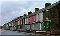
Costa Street, South Bank
All deserted and boarded up and no doubt due to be demolished.
Image: © Mick Garratt
Taken: 13 Dec 2006
0.20 miles