IMAGES TAKEN NEAR TO
High Street, MIDDLESBROUGH, TS6 0NH
Introduction
This page details the photographs taken nearby to High Street, TS6 0NH by members of the Geograph project.
The Geograph project started in 2005 with the aim of publishing, organising and preserving representative images for every square kilometre of Great Britain, Ireland and the Isle of Man.

There are currently over 7.5m images from over14,400 individuals and you can help contribute to the project by visiting https://www.geograph.org.uk
Image Map
Images are licensed for reuse under creativecommons.org/licenses/by-sa/2.0
Notes
- Clicking on the map will re-center to the selected point.
- The higher the marker number, the further away the image location is from the centre of the postcode.
Image Listing (5 Images Found)
Images are licensed for reuse under creativecommons.org/licenses/by-sa/2.0
Image
Details
Distance
1
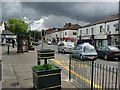
Normanby Cross Roads
Normanby High Street, heading towards Eston.
Normanby Road left, Cleveland Street right.
Taken from near the Co-op.
Image: © Stephen McCulloch
Taken: 3 Jul 2007
0.04 miles
4
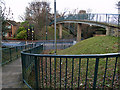
Footbridge over Ormesby Road, Normanby
The bridge carries the path which follows the course of an old mineral railway.
Image: © Stephen McCulloch
Taken: 10 Dec 2008
0.22 miles
5
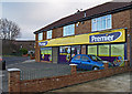
Shop on Hollywalk Avenue
Hollywalk Convenience Stores.
Flatts Lane is the road beyond.
Image: © Stephen McCulloch
Taken: 10 Dec 2008
0.24 miles