IMAGES TAKEN NEAR TO
Cedar Close, MIDDLESBROUGH, TS6 0EB
Introduction
This page details the photographs taken nearby to Cedar Close, TS6 0EB by members of the Geograph project.
The Geograph project started in 2005 with the aim of publishing, organising and preserving representative images for every square kilometre of Great Britain, Ireland and the Isle of Man.

There are currently over 7.5m images from over14,400 individuals and you can help contribute to the project by visiting https://www.geograph.org.uk
Image Map
Images are licensed for reuse under creativecommons.org/licenses/by-sa/2.0
Notes
- Clicking on the map will re-center to the selected point.
- The higher the marker number, the further away the image location is from the centre of the postcode.
Image Listing (3 Images Found)
Images are licensed for reuse under creativecommons.org/licenses/by-sa/2.0
Image
Details
Distance
1
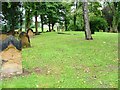
Eston Cemetery
The foundations that can be seen just beyond the tree are those of St. Helens Church. The church was 12th century but it is believed the site was originally a Roman garrison chapel. The name Eston itself is derived from the Saxon "Astune" for an ash tree which is traditionally associated with St. Helen.
Image: © Mick Garratt
Taken: 15 Sep 2005
0.15 miles
2
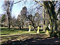
Eston & Normanby Cemetery
This is the approximate original site of St Helen's Church before, following extensive vandalism, it was demolished and rebuilt in Beamish Museum Image
Image: © Graham Hogg
Taken: 26 Mar 2018
0.19 miles
3
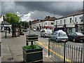
Normanby Cross Roads
Normanby High Street, heading towards Eston.
Normanby Road left, Cleveland Street right.
Taken from near the Co-op.
Image: © Stephen McCulloch
Taken: 3 Jul 2007
0.24 miles