IMAGES TAKEN NEAR TO
Trimdon Avenue, MIDDLESBROUGH, TS5 8RZ
Introduction
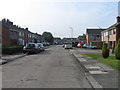
This page details the photographs taken nearby to Trimdon Avenue, TS5 8RZ by members of the Geograph project.
The Geograph project started in 2005 with the aim of publishing, organising and preserving representative images for every square kilometre of Great Britain, Ireland and the Isle of Man.

There are currently over 7.5m images from over14,400 individuals and you can help contribute to the project by visiting https://www.geograph.org.uk
Image Map
Images are licensed for reuse under creativecommons.org/licenses/by-sa/2.0
Notes
- Clicking on the map will re-center to the selected point.
- The higher the marker number, the further away the image location is from the centre of the postcode.
Image Listing (2 Images Found)
Images are licensed for reuse under creativecommons.org/licenses/by-sa/2.0
Image
Details
Distance
2
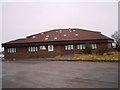
Salvation Army building
This photograph shows a view of the Salvation Army building (West Central Corps) in Trimdon Avenue in the Acklam area of Middlesbrough. The picture was taken from the car park looking in a southerly direction towards Brookfield.
Image: © Philip Barker
Taken: 18 Feb 2010
0.24 miles