IMAGES TAKEN NEAR TO
Kimmerton Avenue, MIDDLESBROUGH, TS5 8LF
Introduction
This page details the photographs taken nearby to Kimmerton Avenue, TS5 8LF by members of the Geograph project.
The Geograph project started in 2005 with the aim of publishing, organising and preserving representative images for every square kilometre of Great Britain, Ireland and the Isle of Man.

There are currently over 7.5m images from over14,400 individuals and you can help contribute to the project by visiting https://www.geograph.org.uk
Image Map
Images are licensed for reuse under creativecommons.org/licenses/by-sa/2.0
Notes
- Clicking on the map will re-center to the selected point.
- The higher the marker number, the further away the image location is from the centre of the postcode.
Image Listing (1 Images Found)
Images are licensed for reuse under creativecommons.org/licenses/by-sa/2.0
Image
Details
Distance
1
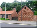
Former Blacksmiths, Acklam Road
Protruding brickwork has been used to show the date of construction of this outbuilding which is believed to have been a blacksmiths forge.
Image: © Mick Garratt
Taken: 14 Jul 2005
0.23 miles