IMAGES TAKEN NEAR TO
Baysdale Walk, MIDDLESBROUGH, TS5 7JA
Introduction
This page details the photographs taken nearby to Baysdale Walk, TS5 7JA by members of the Geograph project.
The Geograph project started in 2005 with the aim of publishing, organising and preserving representative images for every square kilometre of Great Britain, Ireland and the Isle of Man.

There are currently over 7.5m images from over14,400 individuals and you can help contribute to the project by visiting https://www.geograph.org.uk
Image Map (Loading...)


Getting Data...Please wait
Leaflet Map data © OpenStreetMap
Images are licensed for reuse under creativecommons.org/licenses/by-sa/2.0
Notes
- Clicking on the map will re-center to the selected point.
- The higher the marker number, the further away the image location is from the centre of the postcode.
Image Listing (9 Images Found)
Images are licensed for reuse under creativecommons.org/licenses/by-sa/2.0
Image
Details
Distance
6
The Avenue of Trees
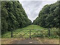
Tracing the original route to the front of Grade I listed former mansion, Acklam Hall. The vast majority of the Hall's former land has been swallowed up into the suburbs of Middlesbrough. The Hall is today a wedding venue and also houses conference facilities and a restaurant.
Image: © David Robinson
Taken: 30 Jul 2021
0.24 miles
7
Tees Valley Hospital
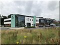
Tees Valley Hospital is a private hospital owned by Ramsey Health Care, built in 2018.
Image: © David Robinson
Taken: 30 Jul 2021
0.25 miles
8

Avenue of trees in Acklam
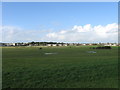
This photograph shows a view of an avenue of trees that runs parallel with St David's Way (the road seen in the right-hand side of the picture). Acklam Sports centre lies to the left of the boundary fence visible in the left-hand side of the image. The picture was taken looking in a southerly direction towards the A1032 road and Acklam cemetery.
Image: © Philip Barker
Taken: 18 Feb 2010
0.25 miles
9
Acklam Hall, Middlesbrough
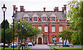
Possibly dating from 1684. It's essentially Classical up to the parapet, but then it veers off at a tangent - the shaped dormers and chimneys probably date from a C19th remodelling. Grade I listed.
It has been a school for some years, is now part of Middlesbrough College but at the time of writing future ownership appears to be in some doubt.
Image: © Stephen Richards
Taken: 24 Jul 2003
0.25 miles