IMAGES TAKEN NEAR TO
Hall Drive, MIDDLESBROUGH, TS5 7EZ
Introduction
This page details the photographs taken nearby to Hall Drive, TS5 7EZ by members of the Geograph project.
The Geograph project started in 2005 with the aim of publishing, organising and preserving representative images for every square kilometre of Great Britain, Ireland and the Isle of Man.

There are currently over 7.5m images from over14,400 individuals and you can help contribute to the project by visiting https://www.geograph.org.uk
Image Map
Images are licensed for reuse under creativecommons.org/licenses/by-sa/2.0
Notes
- Clicking on the map will re-center to the selected point.
- The higher the marker number, the further away the image location is from the centre of the postcode.
Image Listing (12 Images Found)
Images are licensed for reuse under creativecommons.org/licenses/by-sa/2.0
Image
Details
Distance
2
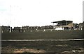
Development site
32 new houses due to start Feb 2013
Image: © Alex McGregor
Taken: 8 Oct 2012
0.13 miles
3
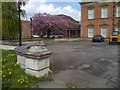
Acklam Hall
A Grade I listed building dating from 1678 and built by William Hustler. In recent times it was used by the Kings Manor School and then Middlesbrough College but is now empty.
Image: © Mick Garratt
Taken: 23 Apr 2014
0.14 miles
5
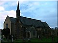
St Mary's Church Acklam
Although the present church was built in 1874 by Sir Thomas Hustler of nearby Acklam Hall there has been a church on this site for over a thousand years. The modern extension behind was built in 1956.
Image: © Mick Garratt
Taken: 15 Nov 2005
0.16 miles
6
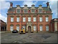
Acklam Hall
A Grade I listed building dating from 1678 and built by William Hustler. In recent times it was used by the Kings Manor School and then Middlesbrough College but is now empty.
Image: © Mick Garratt
Taken: 23 Apr 2014
0.16 miles
7
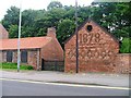
Former Blacksmiths, Acklam Road
Protruding brickwork has been used to show the date of construction of this outbuilding which is believed to have been a blacksmiths forge.
Image: © Mick Garratt
Taken: 14 Jul 2005
0.16 miles
8

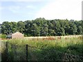
Avenue of trees in Acklam
This photograph shows a view of an avenue of trees that runs parallel with St David's Way (the road seen in the right-hand side of the picture). Acklam Sports centre lies to the left of the boundary fence visible in the left-hand side of the image. The picture was taken looking in a southerly direction towards the A1032 road and Acklam cemetery.
Image: © Philip Barker
Taken: 18 Feb 2010
0.17 miles
9
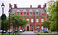
Acklam Hall, Middlesbrough
Possibly dating from 1684. It's essentially Classical up to the parapet, but then it veers off at a tangent - the shaped dormers and chimneys probably date from a C19th remodelling. Grade I listed.
It has been a school for some years, is now part of Middlesbrough College but at the time of writing future ownership appears to be in some doubt.
Image: © Stephen Richards
Taken: 24 Jul 2003
0.17 miles
10
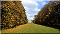
Acklam Hall
A magnificent avenue of trees, one kilometre long leading to the Grade 1 listed Acklam Hall built by Sir William Hustler around 1680. The house has notable interior joinery and plasterwork, which have somehow survived its latter 20th-century life as a school. It is now a business centre, wedding venue and restaurant.
From my blog http://www.fhithich.uk/?p=20355
Image: © Mick Garratt
Taken: 21 Oct 2018
0.17 miles