IMAGES TAKEN NEAR TO
Dorset Close, MIDDLESBROUGH, TS5 6DW
Introduction
This page details the photographs taken nearby to Dorset Close, TS5 6DW by members of the Geograph project.
The Geograph project started in 2005 with the aim of publishing, organising and preserving representative images for every square kilometre of Great Britain, Ireland and the Isle of Man.

There are currently over 7.5m images from over14,400 individuals and you can help contribute to the project by visiting https://www.geograph.org.uk
Image Map
Images are licensed for reuse under creativecommons.org/licenses/by-sa/2.0
Notes
- Clicking on the map will re-center to the selected point.
- The higher the marker number, the further away the image location is from the centre of the postcode.
Image Listing (14 Images Found)
Images are licensed for reuse under creativecommons.org/licenses/by-sa/2.0
Image
Details
Distance
2
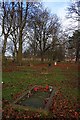
Moses Carpenter's Grave, Linthorpe Cemetery
Image: © Mick Garratt
Taken: 2 Dec 2011
0.17 miles
3
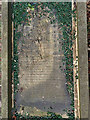
Moses Carpenter's Grave, Linthorpe Cemetery
Image: © Mick Garratt
Taken: 8 Mar 2016
0.18 miles

7

The Linthorpe Community Centre on Linthorpe Road
Image: © Ian S
Taken: 7 Jun 2014
0.21 miles
8

The Linthorpe Assembly Rooms on Linthorpe Road
Image: © Ian S
Taken: 7 Jun 2014
0.21 miles
9
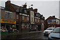
Binks Car Park & The Cleveland Pub
Middlesbrough
Image: © Darren Haddock
Taken: 6 Sep 2006
0.22 miles
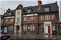
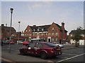
10
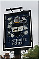
The Linthorpe Hotel
A Sam Smiths pub in Linthorpe.
Image: © Ian S
Taken: 7 Jun 2014
0.24 miles