IMAGES TAKEN NEAR TO
Barker Road, MIDDLESBROUGH, TS5 5ES
Introduction
This page details the photographs taken nearby to Barker Road, TS5 5ES by members of the Geograph project.
The Geograph project started in 2005 with the aim of publishing, organising and preserving representative images for every square kilometre of Great Britain, Ireland and the Isle of Man.

There are currently over 7.5m images from over14,400 individuals and you can help contribute to the project by visiting https://www.geograph.org.uk
Image Map
Images are licensed for reuse under creativecommons.org/licenses/by-sa/2.0
Notes
- Clicking on the map will re-center to the selected point.
- The higher the marker number, the further away the image location is from the centre of the postcode.
Image Listing (12 Images Found)
Images are licensed for reuse under creativecommons.org/licenses/by-sa/2.0
Image
Details
Distance
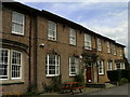
4
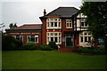
The Cambridge Hotel, Linthorpe
A Sam Smiths public house and Hotel.
Image: © Ian S
Taken: 7 Jun 2014
0.21 miles
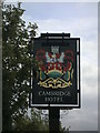
5
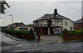
The Cambridge Hotel
This Sam Smith pub is down Cambridge road, Linthorpe, Middlesbrough.
Image: © Ian S
Taken: 23 Jun 2010
0.22 miles
6

The Cambridge Hotel, Linthorpe
A Sam Smiths public house and hotel.
Image: © Ian S
Taken: 7 Jun 2014
0.22 miles
7
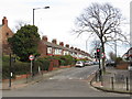
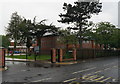
Oxford Road, Middlesbrough
Oxford Road in the suburbs of Middlesbrough.
Image: © Malc McDonald
Taken: 2 Mar 2019
0.22 miles
8
The Cambridge Hotel
A Sam Smith pub down Cambridge Road, Middlesbrough.
Image: © Ian S
Taken: 23 Jun 2010
0.22 miles
9

The Cambridge Hotel, Linthorpe
A Sam Smiths public house and hotel.
Image: © Ian S
Taken: 7 Jun 2014
0.22 miles
10
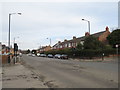
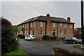
Acklam Road, Middlesbrough
Acklam Road forms part of the A1032 in the suburbs of Middlesbrough.
Image: © Malc McDonald
Taken: 2 Mar 2019
0.23 miles