IMAGES TAKEN NEAR TO
Burlam Road, MIDDLESBROUGH, TS5 5AR
Introduction
This page details the photographs taken nearby to Burlam Road, TS5 5AR by members of the Geograph project.
The Geograph project started in 2005 with the aim of publishing, organising and preserving representative images for every square kilometre of Great Britain, Ireland and the Isle of Man.

There are currently over 7.5m images from over14,400 individuals and you can help contribute to the project by visiting https://www.geograph.org.uk
Image Map
Images are licensed for reuse under creativecommons.org/licenses/by-sa/2.0
Notes
- Clicking on the map will re-center to the selected point.
- The higher the marker number, the further away the image location is from the centre of the postcode.
Image Listing (7 Images Found)
Images are licensed for reuse under creativecommons.org/licenses/by-sa/2.0
Image
Details
Distance
1
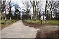
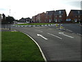
Linthorpe Cemetery from Nursery Lane
This photograph shows a view of Linthorpe Cemetery - apparently the oldest 'working' cemetery in Middlesbrough. The picture was taken near the entrance on Nursery Lane looking in an east-north-easterly direction towards Albert Park.
Image: © Philip Barker
Taken: 4 Mar 2010
0.06 miles

6
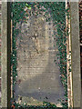
Moses Carpenter's Grave, Linthorpe Cemetery
Image: © Mick Garratt
Taken: 8 Mar 2016
0.23 miles