IMAGES TAKEN NEAR TO
Roman Road, MIDDLESBROUGH, TS5 5AD
Introduction
This page details the photographs taken nearby to Roman Road, TS5 5AD by members of the Geograph project.
The Geograph project started in 2005 with the aim of publishing, organising and preserving representative images for every square kilometre of Great Britain, Ireland and the Isle of Man.

There are currently over 7.5m images from over14,400 individuals and you can help contribute to the project by visiting https://www.geograph.org.uk
Image Map
Images are licensed for reuse under creativecommons.org/licenses/by-sa/2.0
Notes
- Clicking on the map will re-center to the selected point.
- The higher the marker number, the further away the image location is from the centre of the postcode.
Image Listing (6 Images Found)
Images are licensed for reuse under creativecommons.org/licenses/by-sa/2.0
Image
Details
Distance
1
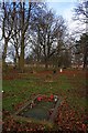
Moses Carpenter's Grave, Linthorpe Cemetery
Image: © Mick Garratt
Taken: 2 Dec 2011
0.09 miles
2
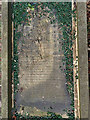
Moses Carpenter's Grave, Linthorpe Cemetery
Image: © Mick Garratt
Taken: 8 Mar 2016
0.09 miles


5
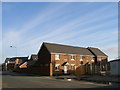
New housing on a brownfield site
The former site of Middlesbrough General Hospital is gradually being transformed into a housing site.
Image: © Carol Rose
Taken: 25 Apr 2007
0.19 miles
6
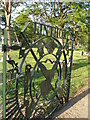
Linthorpe cemetery gates
Commissioned as part of the Linthorpe Cemetery Restoration Project and funded by Heritage Lottery. Put in place with much pomp and newspaper coverage, stolen the next day! Found a few days later, presumably they were too hot to handle. Now put back in their rightful place.
Image: © Carol Rose
Taken: 25 Apr 2007
0.20 miles