IMAGES TAKEN NEAR TO
Westwick Terrace, MIDDLESBROUGH, TS4 3QQ
Introduction
This page details the photographs taken nearby to Westwick Terrace, TS4 3QQ by members of the Geograph project.
The Geograph project started in 2005 with the aim of publishing, organising and preserving representative images for every square kilometre of Great Britain, Ireland and the Isle of Man.

There are currently over 7.5m images from over14,400 individuals and you can help contribute to the project by visiting https://www.geograph.org.uk
Image Map (Loading...)


Getting Data...Please wait
Leaflet Map data © OpenStreetMap
Images are licensed for reuse under creativecommons.org/licenses/by-sa/2.0
Notes
- Clicking on the map will re-center to the selected point.
- The higher the marker number, the further away the image location is from the centre of the postcode.
Image Listing (4 Images Found)
Images are licensed for reuse under creativecommons.org/licenses/by-sa/2.0
Image
Details
Distance
2
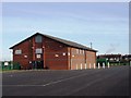
Saltersgill Sports Pavilion
This photograph shows a view of the Saltersgill Sports Pavilion in the Easterside area of Middlesbrough. This building and the surrounding sports fields and amenities are a part of the Teesside University sports infrastructure. The picture was taken looking in a north-easterly direction towards Prissick Farm.
Image: © Philip Barker
Taken: 3 Feb 2010
0.23 miles
3
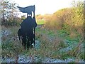
Viking Statue
A Viking warrior guarding the footpath to Tollesby. Denoting the Viking origin of this settlement.
Image: © Mick Garratt
Taken: 18 Nov 2005
0.24 miles
4
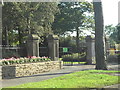
Stewart Park Entrance
Councillor Thomas D Stewart gave the park to the people of Middlesbrough in 1928. The site of the cottage where Captain James Cook was born is in the park.
Image: © Darren Haddock
Taken: 9 Sep 2006
0.24 miles