IMAGES TAKEN NEAR TO
Sutton Way, MIDDLESBROUGH, TS4 3HQ
Introduction
This page details the photographs taken nearby to Sutton Way, TS4 3HQ by members of the Geograph project.
The Geograph project started in 2005 with the aim of publishing, organising and preserving representative images for every square kilometre of Great Britain, Ireland and the Isle of Man.

There are currently over 7.5m images from over14,400 individuals and you can help contribute to the project by visiting https://www.geograph.org.uk
Image Map
Images are licensed for reuse under creativecommons.org/licenses/by-sa/2.0
Notes
- Clicking on the map will re-center to the selected point.
- The higher the marker number, the further away the image location is from the centre of the postcode.
Image Listing (5 Images Found)
Images are licensed for reuse under creativecommons.org/licenses/by-sa/2.0
Image
Details
Distance
3
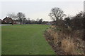
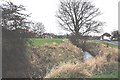
Green belt near Beechwood
This photograph shows a view of the green belt that lies between Beechwood and Linthorpe. The footbridge over Marton West Beck can just be seen in front of the trees on the horizon. Holmwood Avenue lies to the left and Glendale Road is on the right. This picture was taken looking in a southerly direction towards Newham Bridge.
Image: © Philip Barker
Taken: 19 Feb 2010
0.22 miles
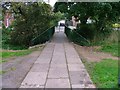
5
Marton West Beck near Beechwood
This photograph shows a view of Marton West Beck as it makes its way north towards Albert Park in Middlesbrough. The picture was taken looking in a southerly direction towards Newham Bridge.
Image: © Philip Barker
Taken: 19 Feb 2010
0.25 miles