IMAGES TAKEN NEAR TO
Marton Grove Road, MIDDLESBROUGH, TS4 2SB
Introduction
This page details the photographs taken nearby to Marton Grove Road, TS4 2SB by members of the Geograph project.
The Geograph project started in 2005 with the aim of publishing, organising and preserving representative images for every square kilometre of Great Britain, Ireland and the Isle of Man.

There are currently over 7.5m images from over14,400 individuals and you can help contribute to the project by visiting https://www.geograph.org.uk
Image Map
Images are licensed for reuse under creativecommons.org/licenses/by-sa/2.0
Notes
- Clicking on the map will re-center to the selected point.
- The higher the marker number, the further away the image location is from the centre of the postcode.
Image Listing (10 Images Found)
Images are licensed for reuse under creativecommons.org/licenses/by-sa/2.0
Image
Details
Distance
1
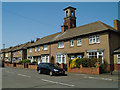
Westminster Road
These used to be the Firemen's houses, the fire station tower is behind the row.
Image: © Mike Guess
Taken: 9 Jun 2006
0.16 miles
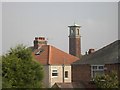
3
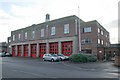
Middlesbrough fire station
Middlesbrough fire station, Park Road South, Middlesbrough, Cleveland
Image: © Kevin Hale
Taken: 27 Nov 2006
0.18 miles
4
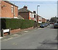
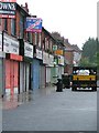
Exeter Road
Linthorpe, Middlesbrough
Image: © Darren Haddock
Taken: 10 Sep 2006
0.19 miles
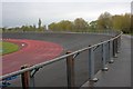
6
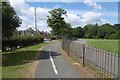
Path in Albert Park
Used by the National Cycle Network.
Image: © Richard Webb
Taken: 10 Aug 2016
0.22 miles
7
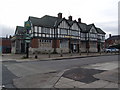
Broadway Pub
Taken just before the Broadway was boarded up and closed.
Image: © Alison Brown
Taken: 12 Nov 2006
0.22 miles
8
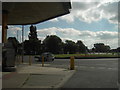
Marton Burn Road Roundabout
Roundabout on junction of Marton Burn Road, Eastbourne and Bishopton Roads. A petrol station is to the left of the picture.
Image: © Darren Haddock
Taken: 9 Sep 2006
0.24 miles
10
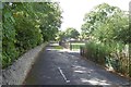
Path, Albert Park
Used by the National Cycle Network.
Image: © Richard Webb
Taken: 10 Aug 2016
0.24 miles