IMAGES TAKEN NEAR TO
Colliers Green, MIDDLESBROUGH, TS4 2DA
Introduction
This page details the photographs taken nearby to Colliers Green, TS4 2DA by members of the Geograph project.
The Geograph project started in 2005 with the aim of publishing, organising and preserving representative images for every square kilometre of Great Britain, Ireland and the Isle of Man.

There are currently over 7.5m images from over14,400 individuals and you can help contribute to the project by visiting https://www.geograph.org.uk
Image Map (Loading...)


Getting Data...Please wait
Leaflet Map data © OpenStreetMap
Images are licensed for reuse under creativecommons.org/licenses/by-sa/2.0
Notes
- Clicking on the map will re-center to the selected point.
- The higher the marker number, the further away the image location is from the centre of the postcode.
Image Listing (13 Images Found)
Images are licensed for reuse under creativecommons.org/licenses/by-sa/2.0
Image
Details
Distance
1
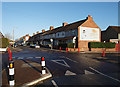
Junction of Saltwells Road and Breckon Hill Road
Looking along Saltwells Road.
The gable end opposite has an old painted advert for Pouf insect killer.
Image: © Stephen McCulloch
Taken: 29 Nov 2007
0.10 miles
2
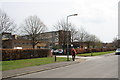
Longlands College and Douglas Street
Soon to move to the new site at Middlehaven Image This building will no doubt be demolished.
Image: © Mick Garratt
Taken: 22 Apr 2008
0.18 miles
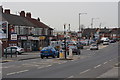
3
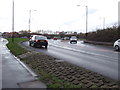
Longlands Road (A1085), approaching roundabout
Heading west.
Image: © JThomas
Taken: 25 Jan 2014
0.18 miles
4
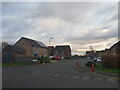
Transporter Way
Looking across Douglas Street onto Transporter Way.
Image: © DS Pugh
Taken: 21 Nov 2020
0.19 miles
5
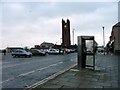
Telephone Box, North Ormesby
With the Parish Church of the Holy Trinity across the market square which is used as a car park on non market days.
Image: © Mick Garratt
Taken: 1 Dec 2005
0.19 miles
8
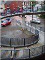
Spiral stairway
Leading down from the North Ormesby flyover to Lytton Street and Saltwells Road.
Image: © Stephen McCulloch
Taken: 11 Jul 2008
0.23 miles
9
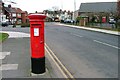
Post Box, Westbourne Grove
Near its junction with Kings Road. St. Alphonsus RC Church Hall is on the right.
Image: © Mick Garratt
Taken: 29 Feb 2008
0.24 miles
10
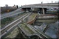
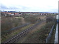
Jumble
A jumble of features: left to right, A1085 just after its junction with the A66 (flyover), Middlesbrough to Whitby railway line and the confluence of Marton West Beck and Middle Beck.
Image: © Mick Garratt
Taken: 11 Jan 2007
0.24 miles