IMAGES TAKEN NEAR TO
Barrington Crescent, MIDDLESBROUGH, TS3 9HZ
Introduction
This page details the photographs taken nearby to Barrington Crescent, TS3 9HZ by members of the Geograph project.
The Geograph project started in 2005 with the aim of publishing, organising and preserving representative images for every square kilometre of Great Britain, Ireland and the Isle of Man.

There are currently over 7.5m images from over14,400 individuals and you can help contribute to the project by visiting https://www.geograph.org.uk
Image Map
Images are licensed for reuse under creativecommons.org/licenses/by-sa/2.0
Notes
- Clicking on the map will re-center to the selected point.
- The higher the marker number, the further away the image location is from the centre of the postcode.
Image Listing (5 Images Found)
Images are licensed for reuse under creativecommons.org/licenses/by-sa/2.0
Image
Details
Distance
1
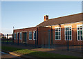
Church on Loxley Road
Formerly Thorntree Community Church, now known as The Christian Centre.
Because of the growing congregation, Sunday services have moved to the St Mary's centre in Middlesbrough town centre. This building is used for community work.
Image: © Stephen McCulloch
Taken: 7 Dec 2007
0.08 miles
2
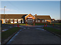
The former Thorntree Library
Thorntree library was closed at the end of 2012 with its services moving to the community centre on Birkhall Road.
In April 2013 the building was destroyed by fire.
Image: © Stephen McCulloch
Taken: 7 Dec 2007
0.09 miles
3
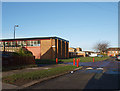
Thorntree Youth and Community Centre
Looking along Birkhall Road towards Beresford Buildings shops on the right.
The road off on the left is Beresford Crescent.
Image: © Stephen McCulloch
Taken: 7 Dec 2007
0.11 miles
4
Beresford Buildings
Shops on Thorntree estate.
Taken from Barsford Road.
Image: © Stephen McCulloch
Taken: 29 Nov 2007
0.18 miles
5
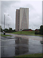
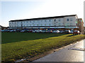
Thorntree House
One of two tower blocks on the Thorntree housing estate.
The main road is Cargo Fleet Lane, with Ruth Avenue in the foreground.
Image: © Stephen McCulloch
Taken: 11 Jul 2008
0.23 miles