IMAGES TAKEN NEAR TO
Pallister Court, MIDDLESBROUGH, TS3 9DG
Introduction
This page details the photographs taken nearby to Pallister Court, TS3 9DG by members of the Geograph project.
The Geograph project started in 2005 with the aim of publishing, organising and preserving representative images for every square kilometre of Great Britain, Ireland and the Isle of Man.

There are currently over 7.5m images from over14,400 individuals and you can help contribute to the project by visiting https://www.geograph.org.uk
Image Map (Loading...)


Getting Data...Please wait
Leaflet Map data © OpenStreetMap
Images are licensed for reuse under creativecommons.org/licenses/by-sa/2.0
Notes
- Clicking on the map will re-center to the selected point.
- The higher the marker number, the further away the image location is from the centre of the postcode.
Image Listing (6 Images Found)
Images are licensed for reuse under creativecommons.org/licenses/by-sa/2.0
Image
Details
Distance
1
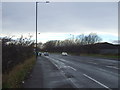
Trunk Road (A1085)
Heading west into Middlesbrough.
Image: © JThomas
Taken: 25 Jan 2014
0.09 miles
3
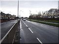
Longlands Road (A1085)
Heading west into Middlesbrough.
Image: © JThomas
Taken: 25 Jan 2014
0.13 miles
5

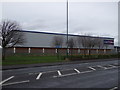
Superstores at Cleveland Retail Park
This photograph shows a view of three of the superstores that are located at the Cleveland Retail Park near the Skipper's Lane industrial estate. The picture was taken looking in a westerly direction towards North Ormesby.
Image: © Philip Barker
Taken: 3 Feb 2010
0.18 miles