IMAGES TAKEN NEAR TO
Delarden Road, MIDDLESBROUGH, TS3 8JR
Introduction
This page details the photographs taken nearby to Delarden Road, TS3 8JR by members of the Geograph project.
The Geograph project started in 2005 with the aim of publishing, organising and preserving representative images for every square kilometre of Great Britain, Ireland and the Isle of Man.

There are currently over 7.5m images from over14,400 individuals and you can help contribute to the project by visiting https://www.geograph.org.uk
Image Map (Loading...)


Getting Data...Please wait
Leaflet Map data © OpenStreetMap
Images are licensed for reuse under creativecommons.org/licenses/by-sa/2.0
Notes
- Clicking on the map will re-center to the selected point.
- The higher the marker number, the further away the image location is from the centre of the postcode.
Image Listing (6 Images Found)
Images are licensed for reuse under creativecommons.org/licenses/by-sa/2.0
Image
Details
Distance
1
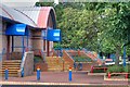
Charlbury Road community centre
Community centre on the Pallister Park estate.
The footbridge in the foreground crosses Middle Beck.
The houses beyond are on Charlbury Road
Image: © Stephen McCulloch
Taken: 20 Nov 2007
0.06 miles
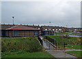
2

Pallister Park
Tennis is one of the variety of sports on offer.
Image: © Mick Garratt
Taken: 19 Jun 2008
0.17 miles
3
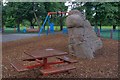
Pallister Park
A fake boulder for the children to play on. Fibreglass I think but apparently resistant to several attempts to torch it.
Image: © Mick Garratt
Taken: 19 Jun 2008
0.18 miles
4
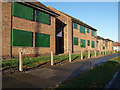
Empty flats, Cottingham Drive
Empty flats on the Pallister Park estate, awaiting demolition.
Image: © Stephen McCulloch
Taken: 29 Nov 2007
0.19 miles