IMAGES TAKEN NEAR TO
Telford Road, MIDDLESBROUGH, TS3 8BL
Introduction
This page details the photographs taken nearby to Telford Road, TS3 8BL by members of the Geograph project.
The Geograph project started in 2005 with the aim of publishing, organising and preserving representative images for every square kilometre of Great Britain, Ireland and the Isle of Man.

There are currently over 7.5m images from over14,400 individuals and you can help contribute to the project by visiting https://www.geograph.org.uk
Image Map
Images are licensed for reuse under creativecommons.org/licenses/by-sa/2.0
Notes
- Clicking on the map will re-center to the selected point.
- The higher the marker number, the further away the image location is from the centre of the postcode.
Image Listing (6 Images Found)
Images are licensed for reuse under creativecommons.org/licenses/by-sa/2.0
Image
Details
Distance
2
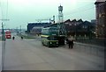
Teesside Railless Traction Board trolleybus outside Cargo Fleet works, 1966
This was the only modern trolleybus network that was not based on earlier tramway operation, and opened in 1919. The system was instigated by the local steel company Bolckow Vaughan (later Dorman Long) who constructed the route but then sold it to Middlesbrough Corporation (33.3%) and Eston Urban District Council (66.7%) before commencement of operation. The steelworks continued to supply electricity until 1955.
The trolleybus is picking up outside the main entrance to what had been the Cargo Fleet Iron Company's work, with head office on the right (still surviving) and the fine lattice clock tower (which no longer exists). Two red United Automobile Services bus can also be seen, on the Middlesbrough – Redcar service.
Image: © Alan Murray-Rust
Taken: 26 Mar 1966
0.16 miles
3
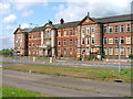
Former Offices of Langbaurgh Borough Council
Built in 1916 for the Cargo Fleet Iron Company. It was last occupied by Langbaurgh Borough Council which evolved into the Redcar and Cleveland Council. These moved into "better" offices at Eston and the building has remained empty.
There are now plans to turn the building into offices and an heritage centre.
Image: © Mick Garratt
Taken: 6 Jun 2005
0.20 miles
4
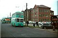
Teesside trolleybus T289 at Cargo Fleet ? 1971
Waiting for a relief crew to take over for the continuation of its journey to Eston, with the offices of the former Cargo Fleet Iron Company behind https://www.geograph.org.uk/photo/15997.
T289 was one of the Sunbeam trolleybuses purchased from Reading when their system closed in 1969. The picture was taken on the final day of operation in April 1971.
This is one of a series of views featuring buses in the 60s, 70s, and 80s. http://www.geograph.org.uk/search.php?i=2114547&displayclass=slide
Image: © Alan Murray-Rust
Taken: 4 Apr 1971
0.20 miles
6
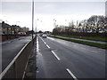
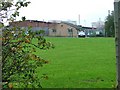
Longlands Road (A1085)
Heading west into Middlesbrough.
Image: © JThomas
Taken: 25 Jan 2014
0.24 miles