IMAGES TAKEN NEAR TO
Dockside Road, MIDDLESBROUGH, TS3 8AT
Introduction
This page details the photographs taken nearby to Dockside Road, TS3 8AT by members of the Geograph project.
The Geograph project started in 2005 with the aim of publishing, organising and preserving representative images for every square kilometre of Great Britain, Ireland and the Isle of Man.

There are currently over 7.5m images from over14,400 individuals and you can help contribute to the project by visiting https://www.geograph.org.uk
Image Map
Images are licensed for reuse under creativecommons.org/licenses/by-sa/2.0
Notes
- Clicking on the map will re-center to the selected point.
- The higher the marker number, the further away the image location is from the centre of the postcode.
Image Listing (16 Images Found)
Images are licensed for reuse under creativecommons.org/licenses/by-sa/2.0
Image
Details
Distance
1
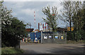
Entrance to Prosser's recycling/scrap yard
Image: © Colin Grice
Taken: 1 Oct 2012
0.10 miles
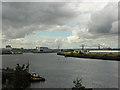
2
River Tees
Wharfs on the south bank of the Tees with Middlesbrough FC's Riverside Cellnet Stadium in the background.
Image: © Mick Garratt
Taken: 23 May 2005
0.10 miles
5
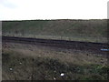
Chicane on the Black Path
The Black Path follows the railway for much of the distance between Middlesbrough and Redcar. For the sake of completeness it has been designated as part of both the Teesdale Way and more recently the England Coast Path. However, the setting of the path through the industrial and post-industrial landscape of lower Tees-side must surely make it the least attractive section of any National Trail.
The path is hard work for cyclists,although there are tyre marks indicating that some do get through. The journey is made a lot more difficult by the installation of this chicane.
Image: © Oliver Dixon
Taken: 21 Mar 2017
0.14 miles
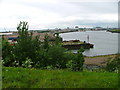
7
River Tees from Cargo Fleet (upriver)
View upriver from the public access know locally as 'Charlie's Mount' on the site of the former Cargo Fleet wharf. The entrance to the former Middlesbrough Dock is on the left, behind the tug base which is also next to the Riverside Stadium. To the right, the river curves away up to the Transporter Bridge
Image: © George Robinson
Taken: 19 Sep 2007
0.17 miles
8
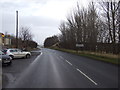
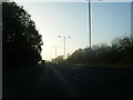
Dockside Road (B1513)
Entering the Borough of Redcar & Cleveland.
Image: © JThomas
Taken: 25 Jan 2014
0.17 miles
9
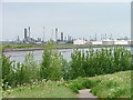
River Tees, Cargo Fleet Wharf
Across the river is the North Tees Oil Refinery operated by Huntsman. Access to the site is strictly controlled. Mobiles, matches and lighters are forbidden for risk of explosion.
Image: © Mick Garratt
Taken: 23 May 2005
0.19 miles