IMAGES TAKEN NEAR TO
TS3 8AQ
Introduction
This page details the photographs taken nearby to TS3 8AQ by members of the Geograph project.
The Geograph project started in 2005 with the aim of publishing, organising and preserving representative images for every square kilometre of Great Britain, Ireland and the Isle of Man.

There are currently over 7.5m images from over14,400 individuals and you can help contribute to the project by visiting https://www.geograph.org.uk
Image Map
Images are licensed for reuse under creativecommons.org/licenses/by-sa/2.0
Notes
- Clicking on the map will re-center to the selected point.
- The higher the marker number, the further away the image location is from the centre of the postcode.
Image Listing (18 Images Found)
Images are licensed for reuse under creativecommons.org/licenses/by-sa/2.0
Image
Details
Distance
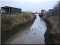
2
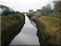
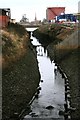
Water Channel from The Leeway
A rather evil slow moving water channel entering the River Tees as seen from The Leeway, Middlesbrough.
Image: © Chris Heaton
Taken: 2 Nov 2010
0.10 miles
7
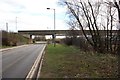
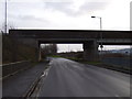
The B1513 road-bridge
This photograph shows a view of the bridge that carries the B1513 road over the
Middlesbrough/Saltburn railway (and the minor road shown in this picture). The B1513 road links the A66 inter-change roundabout at Cargo Fleet with the one at South Bank. The picture was taken looking in an easterly direction towards South Bank.
Image: © Philip Barker
Taken: 27 Mar 2010
0.15 miles
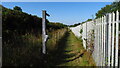
8
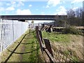
The Black Path at Cargo Fleet
The Black Path follows the railway for much of the distance between Middlesbrough and Redcar. For the sake of completeness it has been designated as part of both the Teesdale Way and more recently the England Coast Path. However, the setting of the path through the industrial and post-industrial landscape of lower Tees-side must surely make it the least attractive section of any National Trail.
Seen here approaching the Works Road bridge. The railway to Redcar lies behind the railings to the left.
Image: © Oliver Dixon
Taken: 21 Mar 2017
0.16 miles
9
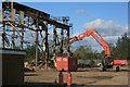
Demolition of Steel Shed
A shed operated by Metnor in the process of being demolished. The sheds were built on the site of one of Teesside's many ironworks.
Image: © Mick Garratt
Taken: 17 Oct 2007
0.16 miles
10
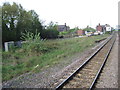
Cargo Fleet railway station (site), Yorkshire
Opened in 1885 by the North Eastern Railway on its line from Middlesbrough to Redcar, this station closed in 1990. View west towards Middlesbrough. The station had been an island platform with the line shown running to the south of it, closer to the tree. The line has now been realigned to run straight, where the platform used to be.
Image: © Nigel Thompson
Taken: 8 May 2010
0.18 miles