IMAGES TAKEN NEAR TO
Westerdale Road, MIDDLESBROUGH, TS3 7RE
Introduction
This page details the photographs taken nearby to Westerdale Road, TS3 7RE by members of the Geograph project.
The Geograph project started in 2005 with the aim of publishing, organising and preserving representative images for every square kilometre of Great Britain, Ireland and the Isle of Man.

There are currently over 7.5m images from over14,400 individuals and you can help contribute to the project by visiting https://www.geograph.org.uk
Image Map
Images are licensed for reuse under creativecommons.org/licenses/by-sa/2.0
Notes
- Clicking on the map will re-center to the selected point.
- The higher the marker number, the further away the image location is from the centre of the postcode.
Image Listing (4 Images Found)
Images are licensed for reuse under creativecommons.org/licenses/by-sa/2.0
Image
Details
Distance
1
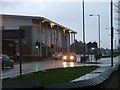
Berwick Hills Leisure Centre and Crossfell Road
Image: © Mick Garratt
Taken: 27 Nov 2005
0.19 miles
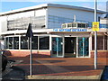
2

Berwick Hills Shops
Sadly somewhat neglected since the opening of the nearby Morrisons supermarket.
Image: © Mick Garratt
Taken: 19 Jun 2008
0.19 miles
4
The Neptune Centre - Berwick Hills
The Neptune Leisure Centre at Berwick Hills in Middlesbrough caters for a wide range of sports and leisure activities. It has a superb swimming pool which acts as the 'home' of Middlesbrough Amateur Swimming Club (MASC). The pool is often used to host swimming galas within the north-east region of the UK.
Image: © Philip Barker
Taken: 26 Nov 2009
0.24 miles