IMAGES TAKEN NEAR TO
Corsham Walk, MIDDLESBROUGH, TS3 7HQ
Introduction
This page details the photographs taken nearby to Corsham Walk, TS3 7HQ by members of the Geograph project.
The Geograph project started in 2005 with the aim of publishing, organising and preserving representative images for every square kilometre of Great Britain, Ireland and the Isle of Man.

There are currently over 7.5m images from over14,400 individuals and you can help contribute to the project by visiting https://www.geograph.org.uk
Image Map (Loading...)


Getting Data...Please wait
Leaflet Map data © OpenStreetMap
Images are licensed for reuse under creativecommons.org/licenses/by-sa/2.0
Notes
- Clicking on the map will re-center to the selected point.
- The higher the marker number, the further away the image location is from the centre of the postcode.
Image Listing (5 Images Found)
Images are licensed for reuse under creativecommons.org/licenses/by-sa/2.0
Image
Details
Distance

3
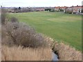
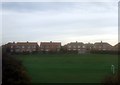
Open land beside the Whitby line
An extensive open space beside the railway to Whitby seen from the footbridge over the line. The distinctive outline of the Transporter Bridge can just be seen on the skyline.
Image: © Oliver Dixon
Taken: 28 Feb 2012
0.24 miles
5
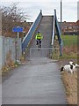
Footbridge near Marton Station
This path close to James Cook Hospital and Marton Station carries the status of bridleway and forms part of an extensive network of cycleways in Middlesbrough. The bridge crosses the Middlesbrough to Whitby line.
Image: © Oliver Dixon
Taken: 28 Feb 2012
0.25 miles