IMAGES TAKEN NEAR TO
Conyers Way, MIDDLESBROUGH, TS3 6LP
Introduction
This page details the photographs taken nearby to Conyers Way, TS3 6LP by members of the Geograph project.
The Geograph project started in 2005 with the aim of publishing, organising and preserving representative images for every square kilometre of Great Britain, Ireland and the Isle of Man.

There are currently over 7.5m images from over14,400 individuals and you can help contribute to the project by visiting https://www.geograph.org.uk
Image Map
Images are licensed for reuse under creativecommons.org/licenses/by-sa/2.0
Notes
- Clicking on the map will re-center to the selected point.
- The higher the marker number, the further away the image location is from the centre of the postcode.
Image Listing (32 Images Found)
Images are licensed for reuse under creativecommons.org/licenses/by-sa/2.0
Image
Details
Distance
1
Whickham Close
Five months on from Mick Garratt's picture, just over the gridline Image and still awaiting demolition.
If they don't start soon there will be nothing left to demolish.
Image: © Stephen McCulloch
Taken: 15 Apr 2008
0.02 miles
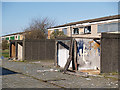
2
Whickham Close
Mostly boarded up and scheduled for demolition. Can't be more than twenty year old.
Image: © Mick Garratt
Taken: 29 Nov 2007
0.05 miles
3
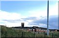
New housing estate in North Ormesby
The tower of Holy Trinity Church showing above the rooftops
Image: © Eirian Evans
Taken: 15 Sep 2021
0.06 miles
4
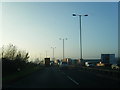
Hoardings Along the A66 Westbound
With part of the National Cycleway system on the right.
Image: © Mick Garratt
Taken: 29 Nov 2007
0.07 miles
5
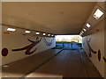
Pedestrian subway under the A66
Subway near North Ormesby.
Suitably decorated on a route to the Riverside Stadium.
Image: © Stephen McCulloch
Taken: 7 Dec 2007
0.07 miles
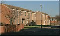
6
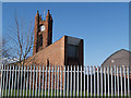
Holy Trinity Church
Viewed from the rear, showing the new church hall.
Image: © Stephen McCulloch
Taken: 15 Apr 2008
0.09 miles
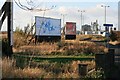
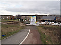
7
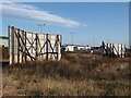
Advertising hoardings by the A66
On the patch of waste ground between the A66 and the Lawson Industrial Estate
Image: © Stephen McCulloch
Taken: 7 Dec 2007
0.09 miles
9

Leaving North Ormesby for Cargo Fleet ? 1971
On the final day of operation of trolleybuses on Teesside. Trolleybus 285, formerly 5, was the last of the original Teesside trolleybuses to run, and is seen here on its way back to depot after the final service run. It is a Sunbeam F4, new in 1950 but rebodied by Roe in the 1960s. This is one of a series of views featuring buses in the 60s, 70s, and 80s. http://www.geograph.org.uk/search.php?i=137652761
This view is the edge of the developed area of North Ormesby where Smeaton Street becomes South Bank Road. The level crossing was a siding serving the Cleveland Timber Yard. Today you will search in vain for any of the features of this view, this https://www.geograph.org.uk/photo/4736609 being the modern view at almost exactly the same point! The new A66 has swept everything away.
Image: © Alan Murray-Rust
Taken: 4 Apr 1970
0.10 miles
10
Old and new
On the left: empty houses on Linsley Close, awaiting demolition.
On the right: new houses and bungalows going up.
Image: © Stephen McCulloch
Taken: 14 Jan 2008
0.11 miles