IMAGES TAKEN NEAR TO
Elizabeth Terrace, MIDDLESBROUGH, TS3 6EN
Introduction
This page details the photographs taken nearby to Elizabeth Terrace, TS3 6EN by members of the Geograph project.
The Geograph project started in 2005 with the aim of publishing, organising and preserving representative images for every square kilometre of Great Britain, Ireland and the Isle of Man.

There are currently over 7.5m images from over14,400 individuals and you can help contribute to the project by visiting https://www.geograph.org.uk
Image Map (Loading...)


Getting Data...Please wait
Leaflet Map data © OpenStreetMap
Images are licensed for reuse under creativecommons.org/licenses/by-sa/2.0
Notes
- Clicking on the map will re-center to the selected point.
- The higher the marker number, the further away the image location is from the centre of the postcode.
Image Listing (24 Images Found)
Images are licensed for reuse under creativecommons.org/licenses/by-sa/2.0
Image
Details
Distance
1
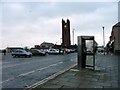
Telephone Box, North Ormesby
With the Parish Church of the Holy Trinity across the market square which is used as a car park on non market days.
Image: © Mick Garratt
Taken: 1 Dec 2005
0.04 miles
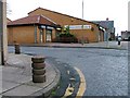
4
North Ormseby Community Centre
A former school, still marked on the map as such, but now used as a community centre.
Image: © Mick Garratt
Taken: 1 Dec 2005
0.12 miles
5

North Ormesby market
Market days Tuesday and Saturday.
Looking towards Holy Trinity church.
Image: © Stephen McCulloch
Taken: 20 Nov 2007
0.13 miles
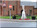
6
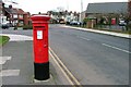
Post Box, Westbourne Grove
Near its junction with Kings Road. St. Alphonsus RC Church Hall is on the right.
Image: © Mick Garratt
Taken: 29 Feb 2008
0.15 miles
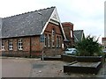
7
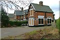
Boarded Up Doctors Surgery, Oakfield Road
Image: © Mick Garratt
Taken: 29 Feb 2008
0.16 miles
8
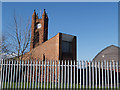
Holy Trinity Church
Viewed from the rear, showing the new church hall.
Image: © Stephen McCulloch
Taken: 15 Apr 2008
0.17 miles
9
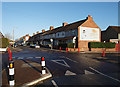
Junction of Saltwells Road and Breckon Hill Road
Looking along Saltwells Road.
The gable end opposite has an old painted advert for Pouf insect killer.
Image: © Stephen McCulloch
Taken: 29 Nov 2007
0.17 miles
10
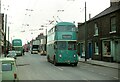
Teesside trolleybus T294 at North Ormesby ? 1971
The trolleybus is about to reverse into Hampden Street before starting off for a clockwise circuit of the Eston route. Taken just a couple of weeks before closure of the system.
The concept of a bus reversing on what was still a main road would simply not be acceptable in modern traffic, but was still quite a common feature of bus operation before the advent of one-person-operation.
This significantly urban location has since been obliterated by the modern A66 interchange.
This is one of a series of views featuring buses in the 60s, 70s, and 80s.
http://www.geograph.org.uk/search.php?i=2114547&displayclass=slide
Image: © Alan Murray-Rust
Taken: 23 Mar 1971
0.18 miles