IMAGES TAKEN NEAR TO
Norfolk Crescent, MIDDLESBROUGH, TS3 0LZ
Introduction
This page details the photographs taken nearby to Norfolk Crescent, TS3 0LZ by members of the Geograph project.
The Geograph project started in 2005 with the aim of publishing, organising and preserving representative images for every square kilometre of Great Britain, Ireland and the Isle of Man.

There are currently over 7.5m images from over14,400 individuals and you can help contribute to the project by visiting https://www.geograph.org.uk
Image Map
Images are licensed for reuse under creativecommons.org/licenses/by-sa/2.0
Notes
- Clicking on the map will re-center to the selected point.
- The higher the marker number, the further away the image location is from the centre of the postcode.
Image Listing (7 Images Found)
Images are licensed for reuse under creativecommons.org/licenses/by-sa/2.0
Image
Details
Distance
1
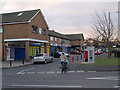
Priestfields Shops
Picture taken across Balmoral Road. Ormesby Road is off to the right.
Image: © Stephen McCulloch
Taken: 10 Dec 2008
0.05 miles
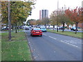
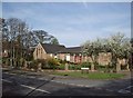
4
View along Lindisfarne Road, Priestfields
Looking towards Glastonbury House and Ormesby Road, with Marham Close off on the right.
Image: © Stephen McCulloch
Taken: 10 Dec 2008
0.12 miles
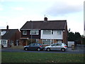
5
Ormesby Methodist Church
Situated on the corner of Ladgate Lane and Pritchett Road.
Image: © Stephen McCulloch
Taken: 8 Apr 2007
0.15 miles
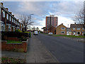
6
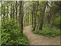
Pennyman Woods
The Pennyman family lived at nearby Ormesby Hall.
Image: © Stephen McCulloch
Taken: 24 Apr 2008
0.19 miles
7
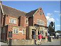
The Fountain Pub, Ormesby
The Fountain Pub on High Street in Ormesby.
Image: © Darren Haddock
Taken: 9 Sep 2006
0.21 miles