IMAGES TAKEN NEAR TO
Church View, TRIMDON STATION, TS29 6FG
Introduction
This page details the photographs taken nearby to Church View, TS29 6FG by members of the Geograph project.
The Geograph project started in 2005 with the aim of publishing, organising and preserving representative images for every square kilometre of Great Britain, Ireland and the Isle of Man.

There are currently over 7.5m images from over14,400 individuals and you can help contribute to the project by visiting https://www.geograph.org.uk
Image Map (Loading...)


Getting Data...Please wait
Leaflet Map data © OpenStreetMap
Images are licensed for reuse under creativecommons.org/licenses/by-sa/2.0
Notes
- Clicking on the map will re-center to the selected point.
- The higher the marker number, the further away the image location is from the centre of the postcode.
Image Listing (12 Images Found)
Images are licensed for reuse under creativecommons.org/licenses/by-sa/2.0
Image
Details
Distance
1
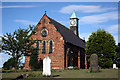
St. Paul's Church
The parish church of Deaf Hill cum Langdale, Trimdon Station
Image: © George Ford
Taken: 2 Aug 2005
0.01 miles
2
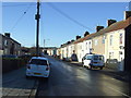
Rodwell Street, Trimdon Colliery
Heading west.
Image: © JThomas
Taken: 11 Jan 2014
0.03 miles
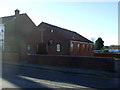
3
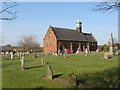
Former church, Trimdon Colliery
A former church in the village of Trimdon Colliery, in County Durham.
Image: © Malc McDonald
Taken: 20 Apr 2019
0.04 miles
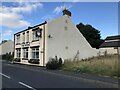
4
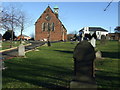
Former St. Paul's Church, Trimdon Station
Now a private residence.
Image: © JThomas
Taken: 11 Jan 2014
0.04 miles
6
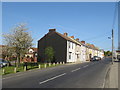
Rodwell Street, Trimdon Station
Rodwell Street in the village of Trimdon Station, in County Durham.
Image: © Malc McDonald
Taken: 20 Apr 2019
0.07 miles
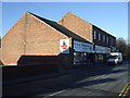
8
The Royal, Trimdon Colliery
The only remaining open pub in the village.
Image: © David Robinson
Taken: 16 Sep 2021
0.12 miles
9

The Royal pub, Trimdon Colliery
On Commercial Street.
Image: © JThomas
Taken: 11 Jan 2014
0.13 miles
10
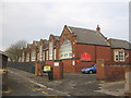
Deaf Hill Primary and Nursery School
Image: © Peter Robinson
Taken: 18 Nov 2010
0.18 miles