IMAGES TAKEN NEAR TO
Trimdon Grange, TRIMDON STATION, TS29 6FD
Introduction
This page details the photographs taken nearby to TS29 6FD by members of the Geograph project.
The Geograph project started in 2005 with the aim of publishing, organising and preserving representative images for every square kilometre of Great Britain, Ireland and the Isle of Man.

There are currently over 7.5m images from over14,400 individuals and you can help contribute to the project by visiting https://www.geograph.org.uk
Image Map (6 Images)


Getting Data...Please wait
Leaflet Map data © OpenStreetMap
Images are licensed for reuse under creativecommons.org/licenses/by-sa/2.0
Notes
- Clicking on the map will re-center to the selected point.
- The higher the marker number, the further away the image location is from the centre of the postcode.
Image Listing (6 Images Found)
Images are licensed for reuse under creativecommons.org/licenses/by-sa/2.0
Image
Details
Distance
1
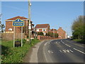
George Street, Trimdon Station
George Street entering the village of Trimdon Station in County Durham. This part of the village is also known as Trimdon Colliery.
There used to be a railway station in the village, but it closed in the 1950s.
Image: © Malc McDonald
Taken: 20 Apr 2019
0.07 miles
2
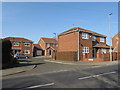
Premier Court, Trimdon Station
Premier Court is a small development of housing in the village of Trimdon Station, in County Durham.
Image: © Malc McDonald
Taken: 20 Apr 2019
0.10 miles
3
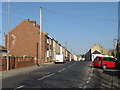
Luke Street, Trimdon Station
Terraced housing on Luke Street in the village of Trimdon Station, in County Durham.
Image: © Malc McDonald
Taken: 20 Apr 2019
0.12 miles
4
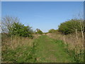
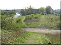
Former railway, Trimdon Grange
The course of a former railway line at Trimdon Grange, in County Durham.
Image: © Malc McDonald
Taken: 20 Apr 2019
0.17 miles
5
Route of former railway, Trimdon Grange
The course of a former railway line at Trimdon Grange, in County Durham.
Image: © Malc McDonald
Taken: 20 Apr 2019
0.17 miles
6
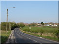
George Street, Trimdon Grange
George Street heading out of Trimdon Grange towards the neighbouring village of Trimdon Station, in County Durham.
Image: © Malc McDonald
Taken: 20 Apr 2019
0.25 miles