IMAGES TAKEN NEAR TO
Trimdon Grange, TRIMDON STATION, TS29 6EY
Introduction
This page details the photographs taken nearby to TS29 6EY by members of the Geograph project.
The Geograph project started in 2005 with the aim of publishing, organising and preserving representative images for every square kilometre of Great Britain, Ireland and the Isle of Man.

There are currently over 7.5m images from over14,400 individuals and you can help contribute to the project by visiting https://www.geograph.org.uk
Image Map (Loading...)


Getting Data...Please wait
Leaflet Map data © OpenStreetMap
Images are licensed for reuse under creativecommons.org/licenses/by-sa/2.0
Notes
- Clicking on the map will re-center to the selected point.
- The higher the marker number, the further away the image location is from the centre of the postcode.
Image Listing (6 Images Found)
Images are licensed for reuse under creativecommons.org/licenses/by-sa/2.0
Image
Details
Distance
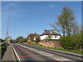
1
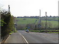
Salter's Lane, Trimdon Grange
Salter's Lane heading southwards out of Trimdon Grange, towards the village of Trimdon on top of the next hill.
Image: © Malc McDonald
Taken: 20 Apr 2019
0.07 miles
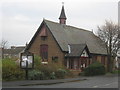
2
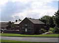
St. Alban's church, Trimdon Grange
St. Alban's church in the village of Trimdon Grange, in County Durham.
Image: © Malc McDonald
Taken: 20 Apr 2019
0.07 miles
3
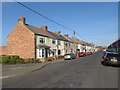
Northside Terrace, Trimdon Grange
Terraced housing in the village of Trimdon Grange, in County Durham.
Image: © Malc McDonald
Taken: 20 Apr 2019
0.08 miles
4
Salter's Lane, Trimdon Grange
Salter's Lane entering the village of Trimdon Grange in County Durham.
Image: © Malc McDonald
Taken: 20 Apr 2019
0.09 miles
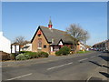
5
St Alban Church Trimdon
Built in 1886, and seats about 120 people. See http://www.achurchnearyou.com/st-albans-trimdon-grange-/ for a link to the church and parish.
Image: © Peter Robinson
Taken: 18 Nov 2010
0.10 miles