IMAGES TAKEN NEAR TO
Russell Crescent, TRIMDON STATION, TS29 6BJ
Introduction
This page details the photographs taken nearby to Russell Crescent, TS29 6BJ by members of the Geograph project.
The Geograph project started in 2005 with the aim of publishing, organising and preserving representative images for every square kilometre of Great Britain, Ireland and the Isle of Man.

There are currently over 7.5m images from over14,400 individuals and you can help contribute to the project by visiting https://www.geograph.org.uk
Image Map (Loading...)


Getting Data...Please wait
Leaflet Map data © OpenStreetMap
Images are licensed for reuse under creativecommons.org/licenses/by-sa/2.0
Notes
- Clicking on the map will re-center to the selected point.
- The higher the marker number, the further away the image location is from the centre of the postcode.
Image Listing (7 Images Found)
Images are licensed for reuse under creativecommons.org/licenses/by-sa/2.0
Image
Details
Distance

4

Deaf Hill Colliery Memorial
The colliery worked from 1877 to 1967. The memorial shows 75 lives lost during that time.
Image: © David Robinson
Taken: 18 Sep 2021
0.13 miles
5
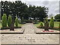
Memorial, Trimdon Colliery
Memorial garden with memorials to those who died in the two World Wars, and those who lost their lives at Deaf Hill Colliery.
Image: © David Robinson
Taken: 18 Sep 2021
0.13 miles
6
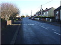
Wingate Road Deaf Hill County Durham
Image: © Peter Robinson
Taken: 18 Nov 2010
0.14 miles
7
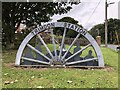
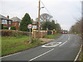
Trimdon Station Village Sign
Village sign commemorating the mining heritage of the local colliery (Deaf Hill colliery)
Image: © David Robinson
Taken: 28 Sep 2021
0.17 miles