IMAGES TAKEN NEAR TO
Chillerton Way, WINGATE, TS28 5FE
Introduction
This page details the photographs taken nearby to Chillerton Way, TS28 5FE by members of the Geograph project.
The Geograph project started in 2005 with the aim of publishing, organising and preserving representative images for every square kilometre of Great Britain, Ireland and the Isle of Man.

There are currently over 7.5m images from over14,400 individuals and you can help contribute to the project by visiting https://www.geograph.org.uk
Image Map
Images are licensed for reuse under creativecommons.org/licenses/by-sa/2.0
Notes
- Clicking on the map will re-center to the selected point.
- The higher the marker number, the further away the image location is from the centre of the postcode.
Image Listing (27 Images Found)
Images are licensed for reuse under creativecommons.org/licenses/by-sa/2.0
Image
Details
Distance


7

Holy Trinity Church
The United Demosis Wingate Grange Church
Image: © George Ford
Taken: 10 Aug 2005
0.07 miles
8
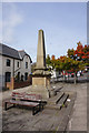
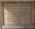
Wingate Grange Colliery Memorial, Wingate
An explosion on the 14th October 1906 killed 26 men.
Image: © Ian S
Taken: 12 Sep 2020
0.08 miles
9
Wingate Grange Colliery Memorial, Wingate
An explosion on the 14th October 1906 killed 26 men.
Image: © Ian S
Taken: 12 Sep 2020
0.08 miles
10

Wingate Grange Colliery Memorial, Wingate
An explosion on the 14th October 1906 killed 26 men.
Image: © Ian S
Taken: 12 Sep 2020
0.08 miles