IMAGES TAKEN NEAR TO
Ellerburne Terrace, WINGATE, TS28 5EY
Introduction
This page details the photographs taken nearby to Ellerburne Terrace, TS28 5EY by members of the Geograph project.
The Geograph project started in 2005 with the aim of publishing, organising and preserving representative images for every square kilometre of Great Britain, Ireland and the Isle of Man.

There are currently over 7.5m images from over14,400 individuals and you can help contribute to the project by visiting https://www.geograph.org.uk
Image Map (Loading...)


Getting Data...Please wait
Leaflet Map data © OpenStreetMap
Images are licensed for reuse under creativecommons.org/licenses/by-sa/2.0
Notes
- Clicking on the map will re-center to the selected point.
- The higher the marker number, the further away the image location is from the centre of the postcode.
Image Listing (6 Images Found)
Images are licensed for reuse under creativecommons.org/licenses/by-sa/2.0
Image
Details
Distance
1
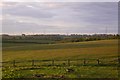
View towards Fairfield
A bright clear evening in Hutton Henry.
Image: © Richard Webb
Taken: 22 May 2016
0.08 miles
2
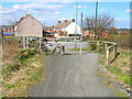
Crossing of the Castle Eden Walkway at Station Town
The Castle Eden Walkway is a foot- and cycle-path which follows the line of a disused railway which traverses County Durham from north to south. Part of the National Cycle Network.
Image: © Oliver Dixon
Taken: 10 Apr 2006
0.12 miles
3
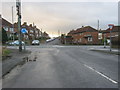
Road from Hutton Henry joining the B1280 at mini- roundabout in Station Town
Image: © Peter Robinson
Taken: 25 Nov 2012
0.13 miles
4
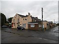
Millbank Terrace, Station Town
Just Eat is a rather good takeaway on the corner. While waiting, I answered a lot of questions from local young people about cycle touring and there was something of a competition to find Station Town on my map. There was a genuine interest in what I was up to which was very refreshing.
Image: © Richard Webb
Taken: 9 Aug 2016
0.17 miles
5
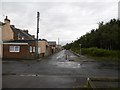
Millbank Terrace, Station Town
There were once two rows here, the easternmost (right of road) one has been demolished.
Image: © Richard Webb
Taken: 9 Aug 2016
0.19 miles
6
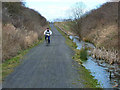
Castle Eden Walkway
The Castle Eden Walkway is a foot- and cycle-path which follows the line of a disused railway which traverses County Durham from north to south. Part of the National Cycle Network.Drainage in cuttings is often a problem on railway paths - solved here by excavating a longitudinal pond alongside the path
Image: © Oliver Dixon
Taken: 10 Apr 2006
0.24 miles