IMAGES TAKEN NEAR TO
WINGATE, TS28 5AN
Introduction
This page details the photographs taken nearby to TS28 5AN by members of the Geograph project.
The Geograph project started in 2005 with the aim of publishing, organising and preserving representative images for every square kilometre of Great Britain, Ireland and the Isle of Man.

There are currently over 7.5m images from over14,400 individuals and you can help contribute to the project by visiting https://www.geograph.org.uk
Image Map
Images are licensed for reuse under creativecommons.org/licenses/by-sa/2.0
Notes
- Clicking on the map will re-center to the selected point.
- The higher the marker number, the further away the image location is from the centre of the postcode.
Image Listing (4 Images Found)
Images are licensed for reuse under creativecommons.org/licenses/by-sa/2.0
Image
Details
Distance
1
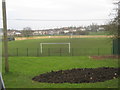
Welfare Park football ground Wingate County Durham
Image: © Peter Robinson
Taken: 18 Nov 2010
0.10 miles
2
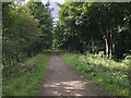
Cycle Path On Former Railway
A stretch of the former railway linking Ferryhill with Hartlepool. Built as an extension of the Hartlepool Dock & Railway to link with the Great North of England Railway and the Clarence Railway it was given the grand title of Great North Of England, Clarence & Hartlepool Junction Railway. The short section from Station Town to Trimdon Colliery is now a cycle route.
Image: © David Robinson
Taken: 18 Sep 2021
0.15 miles
4
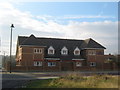
The Medical Centre Front Street Wingate
Image: © Peter Robinson
Taken: 18 Nov 2010
0.24 miles