IMAGES TAKEN NEAR TO
Front Street West, WINGATE, TS28 5AA
Introduction
This page details the photographs taken nearby to Front Street West, TS28 5AA by members of the Geograph project.
The Geograph project started in 2005 with the aim of publishing, organising and preserving representative images for every square kilometre of Great Britain, Ireland and the Isle of Man.

There are currently over 7.5m images from over14,400 individuals and you can help contribute to the project by visiting https://www.geograph.org.uk
Image Map
Images are licensed for reuse under creativecommons.org/licenses/by-sa/2.0
Notes
- Clicking on the map will re-center to the selected point.
- The higher the marker number, the further away the image location is from the centre of the postcode.
Image Listing (28 Images Found)
Images are licensed for reuse under creativecommons.org/licenses/by-sa/2.0
Image
Details
Distance
1
The Medical Centre Front Street Wingate
Image: © Peter Robinson
Taken: 18 Nov 2010
0.03 miles
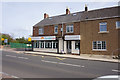
2

Constitutional Club Wingate County Durham
Image: © Peter Robinson
Taken: 18 Nov 2010
0.04 miles
3

Station Road, Wingate
A shower had just passed on a bright Summer evening.
Image: © Richard Webb
Taken: 22 May 2016
0.13 miles

8
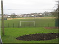
Welfare Park football ground Wingate County Durham
Image: © Peter Robinson
Taken: 18 Nov 2010
0.18 miles
10

Station Road, Wingate
Between Station Town and Wingate (B1280)
Image: © Richard Webb
Taken: 22 May 2016
0.19 miles