IMAGES TAKEN NEAR TO
Bowes Court, HARTLEPOOL, TS27 4TH
Introduction
This page details the photographs taken nearby to Bowes Court, TS27 4TH by members of the Geograph project.
The Geograph project started in 2005 with the aim of publishing, organising and preserving representative images for every square kilometre of Great Britain, Ireland and the Isle of Man.

There are currently over 7.5m images from over14,400 individuals and you can help contribute to the project by visiting https://www.geograph.org.uk
Image Map
Images are licensed for reuse under creativecommons.org/licenses/by-sa/2.0
Notes
- Clicking on the map will re-center to the selected point.
- The higher the marker number, the further away the image location is from the centre of the postcode.
Image Listing (9 Images Found)
Images are licensed for reuse under creativecommons.org/licenses/by-sa/2.0
Image
Details
Distance
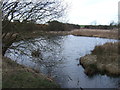
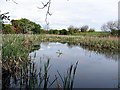
5
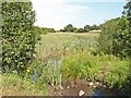
Pond near Benridge, High Hesleden
Viewed from the Haswell to Hart railway path
Image: © Oliver Dixon
Taken: 24 Jul 2006
0.16 miles
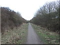
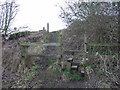
7
Former reservoir
By the side of the Hart to Haswell Walkway
Image: © Kevin Waterhouse
Taken: 14 Jun 2023
0.22 miles
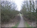
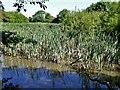
8
Pond adjacent to Haswell to Hart cycle track
Image: © Roger Smith
Taken: 10 May 2009
0.22 miles