IMAGES TAKEN NEAR TO
Parklands Drive, HARTLEPOOL, TS27 4TG
Introduction
This page details the photographs taken nearby to Parklands Drive, TS27 4TG by members of the Geograph project.
The Geograph project started in 2005 with the aim of publishing, organising and preserving representative images for every square kilometre of Great Britain, Ireland and the Isle of Man.

There are currently over 7.5m images from over14,400 individuals and you can help contribute to the project by visiting https://www.geograph.org.uk
Image Map
Images are licensed for reuse under creativecommons.org/licenses/by-sa/2.0
Notes
- Clicking on the map will re-center to the selected point.
- The higher the marker number, the further away the image location is from the centre of the postcode.
Image Listing (11 Images Found)
Images are licensed for reuse under creativecommons.org/licenses/by-sa/2.0
Image
Details
Distance
1

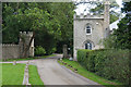
West Lodge
To the Castle Eden Estate
Image: © Kevin Waterhouse
Taken: 14 Jun 2023
0.14 miles
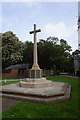
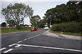
4
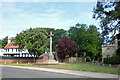
Castle Eden War Memorial
Castle Eden's memorial is on a small triangular green by a bend in the road.
In the background past what looks like a lodge house, a road leads to an estate called Parklands.
Image: © Des Blenkinsopp
Taken: 28 Aug 2022
0.16 miles
5
The Factory in Castle Eden
see http://parishes.durham.gov.uk/castleeden/Pages/AboutCastleEden.aspx
Image: © Peter Robinson
Taken: 28 Jul 2013
0.16 miles
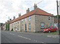
6
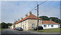
The Factory, Castle Eden
A housing terrace called The Factory.
Something I found on the web about it says "The Factory is the name given to a row of houses located in Castle Eden. During the 1800s, they were used to produce rope and sails."
Image: © Des Blenkinsopp
Taken: 28 Aug 2022
0.17 miles
8
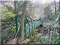
Gunners Pool Bridge, Castle Eden Dene
Difficult to find information about this bridge although I think it may have been built in around 1877. It was built in pieces at nearby Hartlepool and assembled on the site being pulled across the Dene into position by chains and ropes. This is said to have taken place in June 1877.
Image: © Les Hull
Taken: 22 Nov 2006
0.20 miles
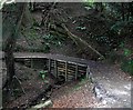
10
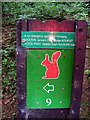
Direction sign with helpful safety information
Image: © Roger Smith
Taken: 23 Aug 2009
0.22 miles