IMAGES TAKEN NEAR TO
The Bungalows, HARTLEPOOL, TS27 4QQ
Introduction
This page details the photographs taken nearby to The Bungalows, TS27 4QQ by members of the Geograph project.
The Geograph project started in 2005 with the aim of publishing, organising and preserving representative images for every square kilometre of Great Britain, Ireland and the Isle of Man.

There are currently over 7.5m images from over14,400 individuals and you can help contribute to the project by visiting https://www.geograph.org.uk
Image Map
Images are licensed for reuse under creativecommons.org/licenses/by-sa/2.0
Notes
- Clicking on the map will re-center to the selected point.
- The higher the marker number, the further away the image location is from the centre of the postcode.
Image Listing (7 Images Found)
Images are licensed for reuse under creativecommons.org/licenses/by-sa/2.0
Image
Details
Distance

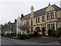
2
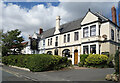
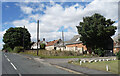
The Ship Inn, High Heselden
Village pub along Mickle Hill Road.
Image: © Des Blenkinsopp
Taken: 21 Aug 2022
0.10 miles
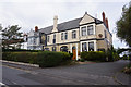
5
The Ship Inn on the main street in High Hesleden
Image: © Carol Rose
Taken: 1 May 2007
0.13 miles
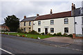
7
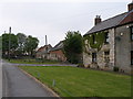
Mickle Hill Road, High Heselden
With some old buildings belonging to High Heselden Farm.
Image: © Des Blenkinsopp
Taken: 21 Aug 2022
0.15 miles