IMAGES TAKEN NEAR TO
Gray Avenue, HARTLEPOOL, TS27 4PE
Introduction
This page details the photographs taken nearby to Gray Avenue, TS27 4PE by members of the Geograph project.
The Geograph project started in 2005 with the aim of publishing, organising and preserving representative images for every square kilometre of Great Britain, Ireland and the Isle of Man.

There are currently over 7.5m images from over14,400 individuals and you can help contribute to the project by visiting https://www.geograph.org.uk
Image Map
Images are licensed for reuse under creativecommons.org/licenses/by-sa/2.0
Notes
- Clicking on the map will re-center to the selected point.
- The higher the marker number, the further away the image location is from the centre of the postcode.
Image Listing (15 Images Found)
Images are licensed for reuse under creativecommons.org/licenses/by-sa/2.0
Image
Details
Distance
1
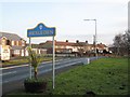
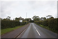
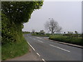
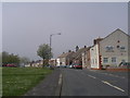
Road into Hesleden
This photograph shows a view of the minor road that goes from the B1281 road into the centre of the village of Hesleden. This picture was taken looking in a southerly direction towards Hesleden Dene.
Image: © Philip Barker
Taken: 17 Jan 2010
0.09 miles
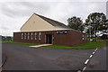
10
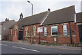
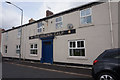
High Hesleden Community Centre on Front Street
Image: © Ian S
Taken: 12 Sep 2020
0.15 miles