IMAGES TAKEN NEAR TO
Bluebell Close, HARTLEPOOL, TS27 4LL
Introduction
This page details the photographs taken nearby to Bluebell Close, TS27 4LL by members of the Geograph project.
The Geograph project started in 2005 with the aim of publishing, organising and preserving representative images for every square kilometre of Great Britain, Ireland and the Isle of Man.

There are currently over 7.5m images from over14,400 individuals and you can help contribute to the project by visiting https://www.geograph.org.uk
Image Map
Images are licensed for reuse under creativecommons.org/licenses/by-sa/2.0
Notes
- Clicking on the map will re-center to the selected point.
- The higher the marker number, the further away the image location is from the centre of the postcode.
Image Listing (12 Images Found)
Images are licensed for reuse under creativecommons.org/licenses/by-sa/2.0
Image
Details
Distance
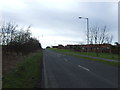
5
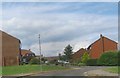
Hall Close off Kember Drive in Blackhall Colliery
Image: © Peter Robinson
Taken: 28 Jul 2013
0.19 miles
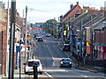
6
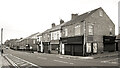
Middle Street, Blackhall Colliery
A town with very logical street naming. This is Middle Street, the main road, with East and West Streets running parallel. In between are First to Eleventh Streets. Easy.
Further along, it's poets.
Image: © Des Blenkinsopp
Taken: 28 Aug 2022
0.22 miles
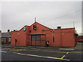
7
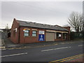
The Blackhall Resource Centre and Police Station
Image: © Ian S
Taken: 3 Feb 2013
0.23 miles
9
For those who worked and those that died
At the Blackhall Pit.
Image: © Ian S
Taken: 3 Feb 2013
0.23 miles
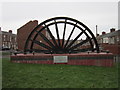
10
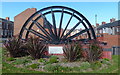
Blackhall Colliery pit wheel monument
Blackhall Colliery closed in 1981. This monument is along Middle Street in Blackhall.
Image: © Mat Fascione
Taken: 26 Aug 2017
0.23 miles