IMAGES TAKEN NEAR TO
East Street, HARTLEPOOL, TS27 4HA
Introduction
This page details the photographs taken nearby to East Street, TS27 4HA by members of the Geograph project.
The Geograph project started in 2005 with the aim of publishing, organising and preserving representative images for every square kilometre of Great Britain, Ireland and the Isle of Man.

There are currently over 7.5m images from over14,400 individuals and you can help contribute to the project by visiting https://www.geograph.org.uk
Image Map
Images are licensed for reuse under creativecommons.org/licenses/by-sa/2.0
Notes
- Clicking on the map will re-center to the selected point.
- The higher the marker number, the further away the image location is from the centre of the postcode.
Image Listing (21 Images Found)
Images are licensed for reuse under creativecommons.org/licenses/by-sa/2.0
Image
Details
Distance
1
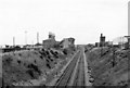
Site of Blackhall Colliery Station
View SE, towards Stockton; Northallerton/Middlesbrough - Stockton - Sunderland - Newcastle secondary main line. Station closed 4/5/64. Colliery continued until 1981.
Image: © Ben Brooksbank
Taken: 6 Sep 1970
0.03 miles
2
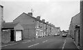
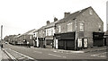
Eighth Street, Blackhall Colliery
Making it easy for the postman, a group of adjacent streets are named from First to Eleventh. I think that's right. I can't see any more on the map.
Image: © Des Blenkinsopp
Taken: 28 Aug 2022
0.05 miles
3
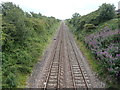
Blackhall Colliery Railway station (site), County Durham
Opened in 1936 by the London & North Eastern Railway on the line from Stockton to Sunderland, this station closed to passengers in 1964 and was subsequently demolished.
View south east towards Blackhall Rocks and Stockton. The two parallel platforms were located in the immediate foreground. No trace apparently remains.
Until the 1980s, this view was dominated by Blackhall Colliery to the left of the line in the middle distance - see Image
Image: © Nigel Thompson
Taken: 1 Aug 2020
0.05 miles
5
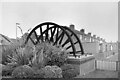
For those who worked and those that died
At the Blackhall Pit.
Image: © Ian S
Taken: 3 Feb 2013
0.08 miles
6
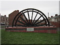
Blackhall Colliery pit wheel monument
Blackhall Colliery closed in 1981. This monument is along Middle Street in Blackhall.
Image: © Mat Fascione
Taken: 26 Aug 2017
0.08 miles
7
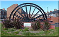
Mine Wheel Memorial, Blackhall Colliery
One of several similar monuments in this area commemorating the former mining industry.
A sea mist has blown in making colour photography rather unrewarding, but this looks ok in B&W.
Image: © Des Blenkinsopp
Taken: 28 Aug 2022
0.08 miles
8
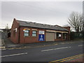
The Blackhall Resource Centre and Police Station
Image: © Ian S
Taken: 3 Feb 2013
0.09 miles
10
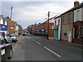
Middle Street, Blackhall Colliery
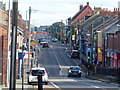
A town with very logical street naming. This is Middle Street, the main road, with East and West Streets running parallel. In between are First to Eleventh Streets. Easy.
Further along, it's poets.
Image: © Des Blenkinsopp
Taken: 28 Aug 2022
0.10 miles