IMAGES TAKEN NEAR TO
Fillpoke Lane, HARTLEPOOL, TS27 4BT
Introduction
This page details the photographs taken nearby to Fillpoke Lane, TS27 4BT by members of the Geograph project.
The Geograph project started in 2005 with the aim of publishing, organising and preserving representative images for every square kilometre of Great Britain, Ireland and the Isle of Man.

There are currently over 7.5m images from over14,400 individuals and you can help contribute to the project by visiting https://www.geograph.org.uk
Image Map
Images are licensed for reuse under creativecommons.org/licenses/by-sa/2.0
Notes
- Clicking on the map will re-center to the selected point.
- The higher the marker number, the further away the image location is from the centre of the postcode.
Image Listing (6 Images Found)
Images are licensed for reuse under creativecommons.org/licenses/by-sa/2.0
Image
Details
Distance
2
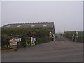
Entrance to Tweddle Children's Animal Farm
On Filpoke Lane.
Image: © Ian S
Taken: 12 Sep 2020
0.06 miles
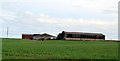
3
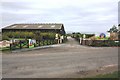
Entrance to Tweddle Black Halls
This photograph shows a view of the entrance to Tweddle Black Halls from the lane that runs between the A1086 road and High Hesleden. The North Sea can just be seen on the horizon. The picture was taken looking in a north-easterly direction towards South Black Halls Farm.
Image: © Philip Barker
Taken: 25 May 2010
0.07 miles
6
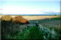
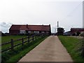
Footpath to Blackhall Rocks
From Tweddle Farm, this footpath follows the field edge past hawthorns not yet stripped by the flocks of fieldfares we often disturb at this time of the year, initially towards the sea, then turning left to reach playing fields and end on the western edge of Blackhall Rocks.
Image: © Andy Waddington
Taken: 30 Nov 2020
0.19 miles