IMAGES TAKEN NEAR TO
Coast Road, HARTLEPOOL, TS27 4BE
Introduction
This page details the photographs taken nearby to Coast Road, TS27 4BE by members of the Geograph project.
The Geograph project started in 2005 with the aim of publishing, organising and preserving representative images for every square kilometre of Great Britain, Ireland and the Isle of Man.

There are currently over 7.5m images from over14,400 individuals and you can help contribute to the project by visiting https://www.geograph.org.uk
Image Map
Images are licensed for reuse under creativecommons.org/licenses/by-sa/2.0
Notes
- Clicking on the map will re-center to the selected point.
- The higher the marker number, the further away the image location is from the centre of the postcode.
Image Listing (32 Images Found)
Images are licensed for reuse under creativecommons.org/licenses/by-sa/2.0
Image
Details
Distance
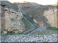
1
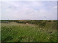
View looking North
Looking North towards Blackhall Rocks from just North of the caravan site.
Image: © Robert Graham
Taken: 5 Jul 2011
0.06 miles
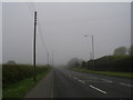
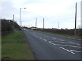
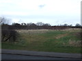
3
A1086 Coast Road at Blackhall Rocks boundary
Image: © Colin Pyle
Taken: 2 Nov 2015
0.16 miles
5
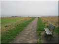
Seat next to path from Blackhall Rocks picnic area to the cliff top
Image: © Peter Robinson
Taken: 14 Nov 2011
0.18 miles
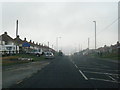
8
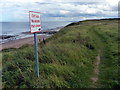
England Coast Path at Blackhall Rocks
Heading south along the Durham Heritage Coast.
Image: © Mat Fascione
Taken: 26 Aug 2017
0.19 miles
9
Steps in the cliffs near Blackhall Rocks
Image: © Peter Robinson
Taken: 27 Nov 2011
0.19 miles
10
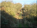
Steps on the northern side of Cross Gill on the Durham Coast
Image: © Peter Robinson
Taken: 27 Nov 2011
0.20 miles