IMAGES TAKEN NEAR TO
Dalton Piercy, HARTLEPOOL, TS27 3HW
Introduction
This page details the photographs taken nearby to TS27 3HW by members of the Geograph project.
The Geograph project started in 2005 with the aim of publishing, organising and preserving representative images for every square kilometre of Great Britain, Ireland and the Isle of Man.

There are currently over 7.5m images from over14,400 individuals and you can help contribute to the project by visiting https://www.geograph.org.uk
Image Map
Images are licensed for reuse under creativecommons.org/licenses/by-sa/2.0
Notes
- Clicking on the map will re-center to the selected point.
- The higher the marker number, the further away the image location is from the centre of the postcode.
Image Listing (7 Images Found)
Images are licensed for reuse under creativecommons.org/licenses/by-sa/2.0
Image
Details
Distance
1
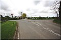
Road junction near Dalton Piercy
This photograph shows a view of the road junction formed by the intersection of Dalton Back Lane (from where the picture was taken) with the minor road that runs between the A19(T) road and Dalton Piercy. Three Gates Farm can be seen on the horizon (to the left of the access track). The picture was taken looking in a north-north-westerly direction towards the A19(T) road.
Image: © Philip Barker
Taken: 1 May 2010
0.05 miles
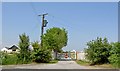
4
Minor road towards Dalton Piercy
Heading north east.
Image: © JThomas
Taken: 11 Jan 2014
0.12 miles
6
Windmill Hotel next to A19 near Dalton Piercy
Image: © Peter Robinson
Taken: 4 Jul 2010
0.19 miles
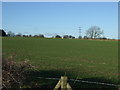
7
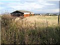
Barn near Dalton Piercy
The Cleveland Hills can be seen on the distant skyline, with the industrial grot of Teesside just this side of them.
Image: © Oliver Dixon
Taken: 14 Nov 2006
0.22 miles