IMAGES TAKEN NEAR TO
Elwick, HARTLEPOOL, TS27 3HD
Introduction
This page details the photographs taken nearby to TS27 3HD by members of the Geograph project.
The Geograph project started in 2005 with the aim of publishing, organising and preserving representative images for every square kilometre of Great Britain, Ireland and the Isle of Man.

There are currently over 7.5m images from over14,400 individuals and you can help contribute to the project by visiting https://www.geograph.org.uk
Image Map
Images are licensed for reuse under creativecommons.org/licenses/by-sa/2.0
Notes
- Clicking on the map will re-center to the selected point.
- The higher the marker number, the further away the image location is from the centre of the postcode.
Image Listing (9 Images Found)
Images are licensed for reuse under creativecommons.org/licenses/by-sa/2.0
Image
Details
Distance
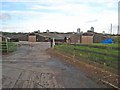
3
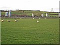
Piggery at Pawton Hill Farm
Pig farming appears to be big business in south-east County Durham. That's sheep in the foreground!
Image: © Oliver Dixon
Taken: 14 Nov 2006
0.12 miles
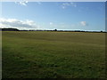
4
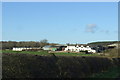
Piggery at Pawton Hill Farm
Pig farming appears to be big business in south-east County Durham.
Image: © Oliver Dixon
Taken: 14 Nov 2006
0.18 miles
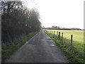
6
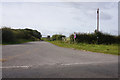
Coal Lane
Heading north west towards Trimdon.
Image: © JThomas
Taken: 11 Jan 2014
0.20 miles
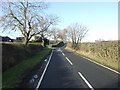
8
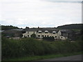
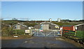
Pawton Hill Farm
Off Coal Lane in Hartlepool borough
Image: © Peter Robinson
Taken: 8 Jul 2009
0.24 miles